
Montana, Big Sky Country. It was a bit of a surprise, though I have to say, out in this part of the world Big Sky Country fits several states. We had visited Little Big Horn during our Dakotas trip in 2006, put it on your MVL (Must Visit List), and thought we knew what the eastern part of the state looked liked. We were not only wrong, the further we drove the more surprised we were, but I’m getting ahead of myself.
Continuing on US Hwy 2 which runs through the top quarter of the state the gas & oil drilling stopped as did most of the crop fields and the landscape became more hilly and drier (this too will change). Just east of the small town of Wolf Point we dropped south on Rt 13 and pretty quickly took Hwy 528. Highway here is just a name not a fact. Running south of the Missouri River this little road turns to gravel almost at once, but good and firm. Abutting the base of lovely dry grass hills on one side and cropped flood plain on the other and a few open range cattle, for you city folk, that means they’re not fenced into a field but can wander where they please 🙂 Eventually the road turns into the hills and if there had been any rain in the last few days we’d have been done as the gravel stopped. This area is all gorgeous open range and there were lots of good looking beef cattle.
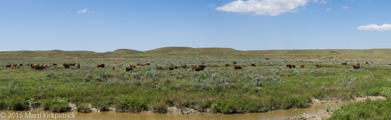
Beef! It’s what’s for dinner!
Hwy 528 ends at paved Rt 24 where we headed north to our campsite, Downstream COE (Corps of Engineers) Project at Fort Peck Dam. This astonishing engineering feat was part of Roosevelt’s New Deal Work Projects. More than 40,000 people came to the area creating 18 boomtowns. In 1936 there was a work force of 10,564 workers directly linked to the dam project! The Fort Peck Dam, the largest hydraulically-filled dam in the world is 50 feet wide at the crest and 3,500 feet at the base and is 21,026 feet long!
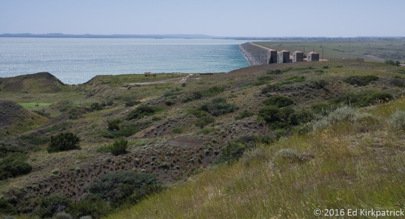
From these four towers of the spillway, the curve into the distance is the dam that runs almost four miles long.
There is a very good museum here which tells the story of the dam project details, boom towns, and one massive earth slide disaster during the construction. This being Montana, home of some major dinosaur fossil finds, there is also an excellent dino section at the museum. I would say if you are out here, do put this on your MVL.
Our next day’s drive included another detour off US Hwy 2 onto O’Brian Rd….road is being polite! Nobody without 4 wheel drive is going down this if there’s been any rain recently! Rutted and rough dried mud it had a delightful photo opportunity of an old falling down homestead. Always a beacon to us 🙂 
We had, and recommend, the daily special lunch at the West Side Restaurant in Malta; homemade tomato soup, chopped steak sandwich, coffee, $20 with tip!!
In Havre, where we stayed for the night, we got the guided tour at Wahkpa Chu’gn (walk-pa-chew-gun) Buffalo Jump. Overlooking the Milk River this prehistoric Indian buffalo jump was discovered in 1961 by 14 year old John Brumley.

The buffalo jump cliff is on the upper right and today is somewhat filled in from what it was when in use. Each of the red buildings houses archeological dig sites.
Three different Indian groups used this site at various times in its 2000 year history to drive buffalo over the cliffs, a much safer way to provide dinner, clothing, tools and survival in an often harsh land! This is the second buffalo jump Ed & I have seen, this is however the only one in the country that is displayed as an “open” archaeological site. Because of this, you can see all the layers as they appeared as they were unearthed. It is very interesting.

Note the upper concentration of bones and then mostly dirt and below another concentration of bones showing the passage of centuries.
The next day was one of those times when all I seemed to be able to say was, “I just can’t get over this, it goes on and on and on forever!”  Field crops were back in acreages that make Iowa look almost second rate. Farmhouses were further apart as were roads. It is pretty with the different crop colors and planting patterns but over all there is a much more lonely feeling brought on by the overwhelming vastness to this landscape. We kept asking each other how did this land, when only endless grass and Indians, affected the pioneers. Can we even begin to imagine, as we zip across this land in our fully equipped motorhome, the courage, determination and surely fear these men and women in their wagons and on foot must have felt? I suppose some might find this landscape boring, but we find it truly humbling… and a reminder of what a great country this is and why we are on this adventure.

Crops and sky. Those tiny bumps on the left are the Sweet Grass Hills a sacred place for the tribes of the plains.

Along “Highway” 528 into the hills.

On THE intersection of Highway 528 and a very long “lane” is this sign posting which direction and how far the local ranches are. Our favorite name is Ortie Twitchell 8.1 miles west.

This, boys and girls is mustard ready for harvest. Can’t say if it’s Grey Poupon or Frenches… but it has a bite to it, yes, we tasted it to confirm it was mustard.

In the Fort Peck Dam Museum display about the horrible earth slide. Eight men died. Six were never found and are interred somewhere in the dam.

A derelict windmill.

O’Brien Road off of US Highway 2

Old farmhouse off O’Brien Road. Note that something big knocked it off its foundations.

The oldest layer of bone debris at Wahkpa Chu’gn Buffalo Jump.
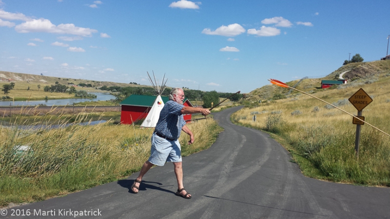
Ed trying his hand at throwing a dart with an atlatl throwing stick. This is going to take practice before dinner makes it back to the teepee.

Approaching the old farmhouse along O’Brien Road.

The harvest is on and they do grow a little wheat out here.

And the prairie comes to an abrupt end at the Rocky Mountains in the distance where Glacier National Park begins our last third of Montana.


Very cool! Thanks again. Another enjoyable read.
Love,
BooBoo and Mike
LikeLiked by 1 person
It does have its own beauty!! Kinda like Ohio! 🙂
I haven’t been out there so I’m enjoying your pics!
Judy
LikeLiked by 1 person
Love every moment of your adventures. Beautiful country!
LikeLike
Love, Love Love this, thank you for sharing and inspiring…Namaste jt
LikeLiked by 1 person
I love Montana and have traveled your routes a few times. The chief engineer of the Fort Peak dam was a Whitman parent many years ago. I have camped below the dam, an act of faith perhaps. Do you know why it is called Wolf Point?
LikeLike
So interesting and awesome, beautiful…pictures are fabulous…where are you headed next? Later…Judy
|
LikeLike
We’re working our way west and then will hang a left and down the coast of Washington and Oregon…not sure just where specifically.
LikeLike
Thank you for sharing your vacation. Great read and pictures !!
LikeLike
Marti one of my favorite states Glacier is to die for Love your blog
Sally o’connor
LikeLike
Cross-country Route 2 is an excellent choice for a true vintage tour of the northern U.S. The glacier-carved landscape is quite lovely heading West. The description here certainly brought it to life. Thank you for the journey.
LikeLike
The photos are just wonderful and capture the beauty of that lonely landscape perfectly. Thanks so much for keeping our eyes and minds involved with your wanderings.
LikeLike
Thank you for sharing these beautiful shots and your post-card. We think of you! It finally cooled off here today and we’ve had a little rain. Quebec City was lots of fun last week,. Margaret
Sent from my iPad
>
LikeLike