• About

Whack-A-Mole Wheels

Whack-A-Mole Wheels

Tag Archives: Lake Superior

Michigan’s Upper Peninsula ~ A New Favorite, Part 1

23 Sunday Sep 2018

Posted by Ed and Marti Kirkpatrick in Travels

≈ 6 Comments

Tags

Copper Harbor, Eagle Harbor, Keweenaw Peninsula, Lake of the Clouds, Lake Superior, Porcupine Mountains, Presque Isle River, Upper Peninsula of Michigan, Yooper

When I was a kid we went to East Lansing, Michigan every summer to visit my maternal grandparents and my uncle’s family in Grand Ledge, or up to Boyne Falls and their farm there.  However, we never went as far north as the UP (Upper Peninsula) so when Ed & I decided to go I was looking forward to it.  We now have another addition for your MVL (Must Visit List) 🙂

Except for Wisconsin on the Southwestern border, the UP is surrounded entirely by water; Lake Superior to the North, the St. Mary’s River to the East and Lakes Michigan and Huron to the Southeast.  All this water has a direct effect on the climate. Generally lovely in the summer, high 70’s low 80’s and often brutal in the winter with 200 plus inches of snow on average and records in the 390’s! it is not for the faint of heart. We are thrilled to say that for our visit we had good temperatures and a number of very pretty, sunny days….finally!

Wanting to stay with the Lake Superior Circle Tour we headed north up RT. 519 for the Porkies, more properly called Porcupine Mountains Wilderness State Park.  On the western tip, just into the Porkies, is the Presque Isle River scenic trail. Our first stop was the suspension bridge which is just a short distance up from where the river flows into Lake Superior.

20180829-_EKP8275

Presque Isle River flowing through the gorge into Lake Superior as seen from the suspension bridge.

20180829-_EKP8297-Pano

Presque Isle River emptying into Lake Superior.

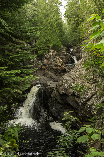
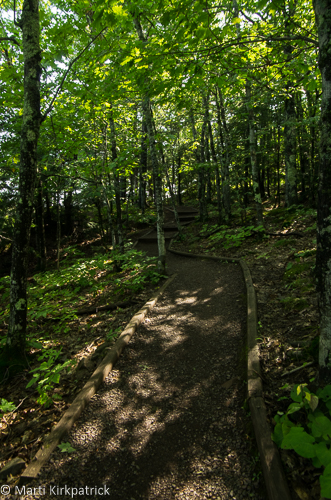
The trail goes up either side of the Presque Isle River and we took the lovely, mostly boardwalk (but lots of steps) trail through the woods. With views of the three waterfalls that follow one another over about a half mile distance, we said yippee to the Sun after the morning fog and clouds!

20180829-_EKP8332

First and lowest of the falls, Manabezho Falls.

20180829-_EKP8350

Second waterfall, Manido Falls.

20180829-_EKP8369

And these are the Nawadaha Falls.

Continuing west on the pretty South Boundary Road of the park we drove to the western edge at Union Bay Campground where we secured a spot before taking the road to Lake of the Clouds.

20180829-_EKP8395

The Carp River flows into and forms Lake of the Clouds at the base of an escarpment in Porcupine Mountains Wilderness.  Apparently, there is really good fishing down there but you have to carry your boat in 3/4 of a mile or wear your waders and after all that effort, it’s catch and release.

20180829-_EKP8399

Looking back up the Carp River along the escarpment.  Something about this place is just magical and the sunshine certainly helped.

Waking to a still sunny day we drove out of the Porkies on RT64 along the coast of Superior to Ontonagon where we headed inland to get RT26 over to Houghton, on the south side of Portage River and Hancock, on the north side.

20180830-_EKP8460

The Ontonagon Lighthouse is in private ownership and we could not visit it.

From here this northern tip is the Keweenaw Peninsula, where until about the mid-1960’s copper has been dug, melted and utilized for thousands of years. We did not explore the copper mine and museum this time but will on our next visit 🙂

20180830-_EKP8559

Float copper, this piece weighs about 1700 lbs. and is the result of glaciers tearing out and leaving it exposed from the native rock.  This type of copper was what ancient peoples utilized as it was on the surface and easy to find.

From Hancock 41 and 26 separate but join back up further north, only to separate again.  We stayed with 26 as it parallels the Lake Superior shoreline.  We stopped at the little town of Eagle River

20180830-_EKP8470

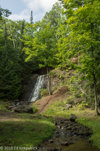
The falls at Eagle River…

20180830-_EKP8472

and the laminated broken arch bridge that carries 26.

and then 3 miles up the road a stop at The Jam Pot operated by the monks of Poorrock Abbey, Holy Transfiguration Skete, a Byzantine Catholic Monastery which was a must do (put it on your MVL).

20180831-Abbey_Cake

That’s cheesecloth it’s wrapped in and the whole cake is soaked in bourbon… a lot of bourbon.  We also bought two different kinds of cookies, Almond cookies and Chocolate, Peanut butter Chip, Raisin, Oatmeal cookies, oh and some Bilberry Jam.  The place is not cheap but Ed could join this sect and be happy.

This area is along Great Sand Bay and indeed there are sand dunes along a good stretch of the road here.

20180830-_EKP8501-Pano

The sand is extremely fine-grained and Marti swears she slid back two for every step up.


There is also a steep stairway (88 steps) down to a beach that called Ed’s name.

20180830-_EKP8518

It was a lovely day for a swim in Lake Superior, it didn’t last long.

20180830-_EKP8527

and yes, it was COLD!

The next town is Eagle Harbor where we stopped and did the lighthouse tour and had a lovely chat with Judy, a Keweenaw County Historical Society volunteer.

20180830-_EKP8534

Eagle Harbor Lighthouse opened in 1851.

20180830-_EKP8532

At Eagle Harbor Light, there is a two drum snow roller that was used to “pank” down fresh snow so horses could pull sleighs.  Used from the 1880s until mechinized snow removal equipment appeared on the scene in the 1920s and 1930s.

The road from Eagle Harbor to Copper Harbor is bumpy, twisty and narrowish, but very pretty.  Copper Harbor is where Fort Wilkins is located and our campground for the night.

20180901-_EKP8587-Pano

Established in 1844, the U.S. Army occupied Fort Wilkins and the troops stationed there were intended to help with local law enforcement and to keep the peace between copper miners and the local Ojibwas which turned out to be unnecessary.

NOTE:  For you fellow camper’s,  we stayed many nights at State Parks as well as popping into State Parks for a day visit.  Whether your stop is overnight or just for the day (or any part of) there is a $9 (out of state) fee.  We highly recommend the yearly recreation pass at $32.  It saved us a lot.

20180901-_EKP8585

Copper Harbor is also the beginning of US 41 the road that allows Michiganers to flee winter for sunny warm Florida.

20180901-_EKP8600

…as this sign in Copper Harbor attests.

Heading back south we also took US 41 which runs down the interior of the peninsula.  Even though it was rainy and foggy this is a beautiful drive.  We planned to stop at Lake Linden Village Campground and recommend this municipal park.  Although the State Recreational Pass does not help, it is only $25 a night. We also had fun watching Torch Lake come closer and closer the night we experienced what may be the heaviest rainstorm, complete with wind and amazing lightning, ever! 🙂

20180901-_EKP8602-Pano

Torch Lake at Lake Linden Village Campground before the rains came.


20180829-_EKP8290

Seriously? only 65 people? on the suspension bridge? at Presque Isle River.

20180829-_EKP8358

Cascades stepping down the river at Presque Isle River State Park.

20180829-_EKP8403-Pano

The view from the top of the walkway at Lake of the Clouds.

20180829-_EKP8433

Marti went for a walk while Ed enjoyed the view at Lake of the Clouds.

20180829-_EKP8435

She’s a sucker for fungus but she doesn’t like truffles anything. Go figure.

20180829-_EKP8458

Lake Superior sunset at Union Bay Campground.

20180830-_EKP8539

The Eagle Harbor Light keeper’s bedroom with original furnishings.

20180830-_EKP8537

The gale of January 29th, 1938 with 50-60 mph gale winds swept waves over the Eagle Harbor Lighthouse and left ice coating the lighthouse and buildings 8 inches thick. Pictured here is the foghorn house.

20180830-_EKP8542

Cottages at Eagle Harbor Light.

20180901-_EKP8584

Another day, another waterfall.  This one is Haven Park Waterfall near Pt. Isabelle on the south coast of the Keweenaw Peninsula.

20180901-_EKP8607

The end of another day and this post, Ed contemplates where we are going next.


Just A Bit of Minnesota & Wisconsin

12 Wednesday Sep 2018

Posted by Ed and Marti Kirkpatrick in Travels

≈ 5 Comments

Tags

Chippewa Falls, Devils Kettle Falls, Lake Superior, Minnesota, Naniboujou Lodge, Split Rock Lighthouse, Waterfalls, Wisconsin, Wisconsin Coulees, Wonewoc

Crossing back into the United States at Grand Portage, Minnesota we had the nicest US Board Patrol agent we’ve ever had coming home.  Unfortunately, the weather was still grey and foggy and being married to a photographer there were some grumbly noises about flat light now that there were actually more open views of Lake Superior.  Oh well, that seems to be our lot on this trip.

Our first stop continuing on Superior Scenic RT 61 was at Judge C.R. Magney State Park where we wanted to hike the Devil’s Kettle Falls trail.

20180819-_EKP7968

Until 2017 there has been much speculation about the mystery of Devils Kettle.  Objects tossed in the hole (top left) never came out below the falls so the story was it was the Devil’s Kettle, things just disappeared into the netherworld. Last year, a hydrologist suggested the water going in be measured going in against the water coming out.  Come to find out, it was almost exactly the same. The water is not disappearing and the objects tossed in are being pulverized by the incredible force of the water pouring down into the kettle.

20180819-_EKP7991

Below Devil’s Kettle.

After our lovely walk, a Sunday Brunch at the Naniboujou Lodge was definitely on our day’s schedule. Planned and built as an exclusive private club, Naniboujou had the misfortune of opening in July of 1929, followed by the disastrous October stock market crash that Fall.  Foreclosure came in 1935.  Now privately owned, and open to the public we highly recommend Sunday Brunch….best bacon I ever had!!

20180819_132309

From the brochure, “Probably the most memorable aspect of the lodge is the wondrously painted 30 x 80 foot dining room. Antoine Goufee, a French artist, painted Cree Indian designs over the walls and the twenty-foot-high domed ceiling (resembling the shape of a canoe). “

Completely stuffed, but happy, we continued south to the Cascade River State Park where we would camp for the night.  After using most of our leveling blocks 😦 we walked back the Cascade River Trail enjoying the waterfalls flowing down the gorge.

20180819-_EKP8013

Looking down the gorge at Cascade Falls State Park.

20180819-_EKP8029

We walked a ways upstream encountering several more falls along the way.

20180819-_EKP8041

Cascade Falls.

We stopped briefly at Tettegouche State Park where at the visitor center there is an excellent display of different kinds of scat, so you too can know what wild animal left their “calling card” for you.

20180820-_EKP8069-Pano

The gravel and sand beach at Tettegouche State Park on Lake Superior.

The Split Rock Lighthouse was an especially fun stop.  An advantage to cool grey weather is using the kitchens wood burning oven is not uncomfortable.   Ed was delighted to find the “lightkeeper’s wife” was just taking her ginger bread cake out and yes, he could certainly have a taste 🙂

20180820-20180820-_EKP8090

Split Rock Lighthouse.

20180820-_EKP8111

The flat strap of copper running up the side of the light is a grounding rod for lightning strikes.

20180820-20180820-_EKP8122

This is the recipe card for the Ginger Bread Cake from the last keeper’s wife written in her hand.

20180820-_EKP8103

The 3rd order bi-valve Fresnel lens in the light at Split Rock.

The Silver Creek Tunnel (about 5 miles north of Two Harbors) was completed in 1994 and we stopped to walk the section of RT 61 that the tunnel replaced.  Taking 3 years to complete, 500,000 cubic yards of rock had to be blasted and removed to accommodate this 1,344 foot long pass through Silver Creek Cliff.

20180820-_EKP8145

The old original road passes to the left up the hill.  There was no room for error driving around the steep cliff before the tunnel was built in 1994.  Rocks were falling down and the cliff was washing out.

Leaving Minnesota at Duluth, we agreed this drive along Lake Superior was very different than our drive in Canada.  Geared towards tourists, there were many more scenic overlooks and because of the large number of waterfalls many places to stop and take a walk or a full-blown hike.  Even though the weather wasn’t the best, and we moved along pretty quickly, we enjoyed ourselves.

Next up, of course, was Wisconsin and we stopped for the night at Amnicon Falls State Park where first thing in the morning we took the short walk to enjoy the falls.

20180821-_EKP8170-Pano

Unlike most falls we have seen so far, there was little water in the river here due to a drought this summer. The bridge is a Horton bridge, Horton promoted his design, of a bow-strung truss as cheaper and stronger.  The roof was added by the CCC in 1939 then replaced in 1941 after snow collapsed it and then again in 1971 when vandals set it on fire.

Taking US 2 to RT 13 to continue our Lake Superior tour, we stopped in Cornucopia at Marine Harbor.

20180821-_EKP8188

The locals really like to play at the playground at Cornucopia’s little park.


At the small store at Halvorson Fisheries, we bought some of their brown sugar smoked whitefish and a small container of smoked whitefish dip.  Whitefish (Lake Whitefish) is a/the major fish coming out of Lake Superior.  It’s in all the restaurants and shops and being very mild in flavor, very popular.  The gentleman we chatted with in Halvorson’s told us “It don’t get any better than that dip, and the fish…I eat it 3, 4 times a week!”  After our own taste tests… the dip, with crackers… not bad; the smoked, with crackers… not bad;  battered & fried with tartar sauce… not bad…; as chowder….good…..BUT…if given a choice, Cod is better. 🙂

20180821-_EKP8189

Right behind Halvorson Fisheries in Marine Harbor, Cornucopia.

We have been in Wisconsin a couple of times over the years and really loved the south/west/central area.  Our favorite is the coulee area.  Water erosion has cut deep, steep-sided valleys with relatively flat and narrow ridges. Heavily farmed with mostly corn, soybeans, hay and alfalfa. Fields flowing over the rolling curves, highs and lows of the landscape, it is unlike almost anywhere we’ve ever been. It’s incredibly beautiful.  Unfortunately, every time we’ve been here the light has been just flat and photographs just don’t do it justice, but that’s ok, we will be back again.

20180826-20180826-_EKP8224-Pano

Wisconsin Coulee crops.  It has been raining here and the crops and fields are very lush.

20180826-_EKP8231-Pano

More coulee area farms.


20180819-_EKP8036

Water swirling everywhere.  We are astonished at how much water there is in this part of the country.

20180820-_EKP8048-Pano

We have joked to ourselves about how this is our Waterfall trip.  Here’s another one at Cross River along the North Coast Road in Minnesota. Notice the potholes worn in the rock by sand and gravel swirling around.

20180820-_EKP8088

Local flora and fauna at Tettagouch State Park.

20180820-_EKP8109

Keeper’s houses at the Split Rock Lighthouse. 

20180822-_EKP8201-Pano

Just into Wisconsin, the Sun popped out for a couple of hours and then was gone for several days.  We had some horrific torrential rainstorms while we were in Wisconsin.  Just south of us one night, Madison got 15″ of rain in just a couple of hours.

20180822-20180822_145227

We holed up in Chippewa Falls, Wisconsin for a couple of days and we discovered Leinenhugel’s Brewery.  We took the tour even though the place was closed for repairs.  We could only see the bottling line which was pretty boring.  Ed did get to sample five of their brews plus some of Marti’s five. They all tasted exactly the same, like fizzy water… Ed’s preferred drink is Guinness.

20180823-20180823_133238

After visiting a farmers market in Chippewa Falls we had yummy fresh veggies!  Walking back to our rig Ed saw this shadow on a wall. 

20180826-_EKP8244

We saw this old-timey Texaco station somewhere in a small town in Wisconsin.

20180827-_EKP8251

The bustling metropolis of Wonewoc, Wisconsin.  We have actually been to this little place three times on three separate trips.  The first time in 2006 Ed found and bought a lovely big wooden Century camera dating to about 1906.

20180827-_EKP8256-Pano

The Sun is teasing us and later came out for a lovely couple of days.

Weather, i.e. the light, has been a big issue this whole adventure.  That being said, the Minnesota Lake Superior Circle route is lovely.  The Wisconsin Coulee Area is almost magical and we recommend all of this for your MVL (Must Visit List)….just try to do it when the Sun is shining 🙂

Northwestern Ontario ~ Water, Trees, Trees & Water

25 Saturday Aug 2018

Posted by Ed and Marti Kirkpatrick in Travels

≈ 8 Comments

Tags

Aguasabon Falls & Gorge, Butter Tarts, Fort William Historical Park, Gitchi Gumi, Lake Superior, Ontario, Pickle Lake, Thunder Bay

With our plan having now evolved to checking out Lake Superior on our way to Thunder Bay we crossed into Ontario on RT 101 where the traffic was almost at once much lighter.  Don’t know why but it gave Ed a break as he regularly tends to drive on the shoulder (when there is one) to allow folks to pass us easily.  We were headed for Wawa where we’d take the TCH 17 which is the Ontario part of the Lake Superior Circle Tour.  NOTE: The Trans Canada Highway is generally just called the TCH but notice that it has a number. That is because it’s actually many different roads. It can be equated to our interstates.

The landscaped changed with more rock and initially some small mountains, but that didn’t last although the rock did.

20180809-_EKP7619

Granted, there is no rock in this picture but there’s a hill in the background and like the title says, trees and water. It’s pretty anyway and it is what we were seeing as well.

In Wawa at the Embassy Restaurant, which has a very grand name for a very down home place, we had a really good cheeseburger. Believing it’s always right to help folks hanging on, we recommend you too stop for a meal if in the area.

20180809-IMG_20180809_131613570-2

In the Embassy Restaurant there was this wonderful wall hanging of neckties and what I think can be described as an First Nation mask.  As artists, we are very sorry to not be able to give credit where it is due.  The young man who waited on us knew nothing about it except it had been there forever.  Isn’t it fun?

20180809-_EKP7636

The good folks of Wawa when the TCH bypassed the town in 1960 wanted something to slow folks down and bring them into town so they made a giant Canada Goose sculpture.  There is a newer one down by the visitor’s center but we liked this old guy.

Our next stop for the night was in Marathon another town barely hanging on but they have a very nice municipal park, Penn Lake Park where we stayed two nights. In town there is also one of the nicest coin laundries I’ve ever used, although it was a bit expensive. There’s also Rumours where we had our first homemade butter tarts WOW!  I don’t particularly care for real sweet and rich but OMG!!!  They are reason enough to go to Marathon, Ontario, YUM!

20180810-20180810_185949

Butter, butter and raisins, cinnamon, butter, sugar and butter.  YUM!

20180812-_EKP7692-Pano

Early morning at Penn Lake Park.

We stopped for the short walk out to Aguasabon Falls & Gorge.  This is a man made waterfall!  In the late 1940’s in an effort to assure ample water for the Aguasabon Generating Station, Ontario Hydro built a dam at the northern end of Long Lake to redirect its northern flow, south.  This in turn, massively enlarged Hays Lake.  The spillway from Hays created these falls.

20180812-_EKP7700

Aguasabon Falls & Gorge

We have been chuckling to ourselves because for a great deal of this route is too far away from Lake Superior to see it.  Where it is visible it’s often through trees and just “oh there’s water out there”.  We’ll see a sign indicating a lookout (in the US we call that a scenic view) and there is nothing to see and/or too many trees to see anything anyway.  Several times there’s a lovely view but the official lookout is past the good view!   It also didn’t help that the light was really crummy.  We never took a picture because the view was crummy.

20180812-_EKP7710

At Terrace Bay we did actually get a chance to go down to Lake Superior.  It was fun to put our feet in the water but you can see the light across the lake is just crummy and smoky from fires in Ontario up way north and British Columbia.

We stopped for the night at Sleeping Giant Provincial Park which is on Marie Louise Lake.

20180812-_EKP7732

Lake Marie Louise and Marti cooling her heels. The Sun had come out at the end of the day, Yay!

In the morning we drove on down 587 to the end of Sleeping Giant where there’s a very narrow loop through the small summer cottages by Lake Superior.  Then back north up RT 587 to the 5.6 mile long dirt road that goes to the excellent Thunder Bay Lookout.  This is not a road for anything larger than us, (nor wary drivers) and the end is a bit hazardous to tires, but we are so glad we went!

20180813-_EKP7746

For the first time ever, we actually drove on ROCK. There were major cracks and holes to avoid.  Roadside assistance was not going to be an option…

20180813-_EKP7751-Pano

These are the tallest cliffs in Ontario, a lot of meters above Lake Superior.

20180813-_EKP7794

This the cantilevered platform you walk out on in order to see the previous picture.  You have no idea what it took for Marti to go stand out there but boy was it worth it.

After enjoying the view of Thunder Bay and carefully driving back down we headed for Fort William Historical Park just south of the city where we camped for two nights.  NOTE:  Contrary to what the webpage says, the campground is not on the banks of anything and certainly not wilderness, but it is convenient with good wifi.   

20180813-_EKP7878

However if your are lucky, you will have good neighbors like we did with Paul and Anita.  If you are really lucky, somebody like little Izzy will come jump in your lap!

The original Fort William (so named in 1807) was established in 1803. The North West Company (Nor’Westers ) had been operating their fur trade out of Grand Portage but after the signing of the Jay Treaty between England and America ceded that area to the US,  Nor’Westers moved to Canada to avoid paying US taxes. Initially located at the mouth of the Kaministiquia River near Lake Superior the site was lost in the 1880’s to railroad tracks and coal piles.  This reconstructed Fort William Historical Site further up the Kaministiquia River opened in 1973 and is most impressive in size and authenticity.

20180813-_EKP7860-Pano

This is the common area in the middle of the fort.  The layout of the buildings, what they looked like and how they were built was all taken from exacting drawings and notes recorded by Lord Melrose at the time.

20180813-_EKP7842

The garden area.

20180813-_EKP7858

The Magazine and Armory is only one of two buildings in the complex to have a tin roof.  The reason was to allow any accidental explosions to go up rather than out which would destroy the building.

20180813-_EKP7859

As you can see, the corners of the Armory were strengthened by mounding dirt at the corners to help contain any booms.

20180813-_EKP7811

Fort William Historical Park contains 42 reconstructed buildings, a reconstructed Ojibwa village, and a small farm all populated by authentically dressed reenactors. You may notice in this picture that even the window glass used shows the waffling of old glass.

As I mentioned in our last post some of this particular adventure has been about “just to say we’ve been there” and to that end Ed wanted to go to Pickle Lake.  This is the furthest north one can drive in Ontario Province on paved road.

20180816-_EKP7938

Greetings at Pickle Lake where someone has a sense of humor.  Truth is there is no reason to come here unless you want to fish or hunt.

Our last two nights in Canada were at Kakabeka Falls Provincial Park  just north of Thunder Bay.

20180814-_EKP7913-Pano

Kakabeka Falls.

20180814-_EKP7909-Pano

Another view from above the falls.  The previous photo was taken from the platform on the right hand side of this photo.

We have enjoyed this visit to Canada but are happy to now be back to the States.  We have stayed in many provincial and municipal parks this time and recommend them…HOWEVER….most have varying degrees of leveling issues, some pretty bad.  Most only have electric at some/most sites.  Water is generally available but not always.  Dump stations also may not be available.  Electric, especially in Ontario can be a LONG ways away from your site.  We worked things out but we have lots of leveling blocks, extra water hose and electric cable and in truth aren’t too particular.  So while we do recommend staying in these parks, go prepared and with a sense of humor…or at least a bottle of wine after you’re settled in 🙂


20180810-_EKP7646

The Williams Gold Mine just east of Marathon has produced nearly 21 million ounces of gold.  That’s a lot of bling.

20180812-_EKP7703

The very serious viewing platform overlooking Aguasabon Falls & Gorge.

20180813-_EKP7815

An interesting detail of pinning a joist of some kind to the vertical end wall of the log buildings.  We have never seen this sort of work before and we used to live in an old log cabin.

20180813-_EKP7834

Marti is a sucker for baby goats.  This reenactor was admittedly delighted to talk to folks who have actually raised farm animals.  We were equally delighted to chat with her both about period farming practices and her own modern day chicken farming.

20180813-_EKP7837

Ed liked this Nanny goat.

20180813-_EKP7847

The canoe building shed was just amazing.  This canoe is called a Montreal and had a 5 foot beam, was about 2 feet deep and we think it was 27 feet long.  It was used to transport cargo on the big waters of Lake Superior, Gitchi Gumi.

20180813-_EKP7852

These are rolls of birch bark to be used making the canoes.  Ed estimates each roll to be about 8-10 feet long which would mean the tree it was cut from approached 3 feet in diameter.  The barks were about a quarter inch thick.  Unfortunately, there was nobody in the building to ask but the display was pretty impressive.

20180813-_EKP7855

Just some things on a bench in the canoe building.

20180813-_EKP7857

The barracks at Fort William.

20180813-_EKP7871

An Anishnawbe encampment just outside the fort.

20180813-_EKP7873

The furs, basically the whole reason the fort was here, came from the Anishnawbe who traded them for European goods. Throughout the fort there were furs everywhere and they were all real and of very high quality.

20180814-_EKP7881

Kakabeka Falls.

20180816-_EKP7937

At the end of the paved road at Pickle Lake.  They ain’t kidding around.

20180817-_EKP7941

We wandered back RT 622 on our way back south from Pickle Lake to camp that night at Kakabeka Falls. This was one of the prettiest roads we encountered in Ontario and a large portion of it, 32KM was nicely graded gravel with some kind of goo on it to keep down the dust. The gooey mud got all over the bottom of the rig.

20180817-_EKP7943

A nice scene along RT 622.

20180813-_EKP7774

A parting shot from the abyss, the Thunder Bay Lookout at Sleeping Giant Provincial Park.

Enter your email address to follow this blog and receive notifications of new posts by email.

Join 221 other subscribers

View Recent Posts

  • Cod Jigging and New Friends! March 2, 2020
  • Grand Tetons ~ Yellowstone October 11, 2019
  • Beauty & Bones ~ Dinosaur National Monument September 29, 2019
  • Wyoming ~ In the Medicine Bow Corner September 25, 2019
  • A Bit of Western Nebraska September 5, 2019

Get Caught Up

Blogs We Follow

  • john pavlovitz
  • Take To The Highway
  • Kelly Time
  • HowToRVgeeks
  • WANDERTOPIA
  • BoomerCafe ... it's your place
  • Island Girl Walkabout
  • The Online Photographer
  • Technomadia
  • Wheeling It: Tales From a Nomadic Life

Categories

Blog Stats

  • 24,723 hits

Blog at WordPress.com.

john pavlovitz

Stuff That Needs To Be Said

Take To The Highway

Kelly Time

HowToRVgeeks

WANDERTOPIA

BoomerCafe ... it's your place

Island Girl Walkabout

Hector and Brenda on a journey of discovery

The Online Photographer

Technomadia

Adventures in Nomadic Serendipity

Wheeling It: Tales From a Nomadic Life

On the Road Since 2010, Traveling Across USA & Europe With Pets

  • Follow Following
    • Whack-A-Mole Wheels
    • Join 184 other followers
    • Already have a WordPress.com account? Log in now.
    • Whack-A-Mole Wheels
    • Customize
    • Follow Following
    • Sign up
    • Log in
    • Report this content
    • View site in Reader
    • Manage subscriptions
    • Collapse this bar
 

Loading Comments...