
Tags
Baie-Comeau, Dolbeau-Mistassini, Ferme Tournesol, Godbout, Hydro-Quebec, Manic 2, Quebec, Route du Fjord
Having made the decision to continue our travels in Quebec on the north shore of the St. Lawrence, we headed for the ferry docking town of Matane. From here the ferries do the run across (and back) to either Baie-Comeau or Godbout, with either trip lasting just over two hours. Ed had researched the ferry schedule a couple of days earlier and said that the 8AM ferry ran to the more northern town of Godbout and the later 2:30 ferry ran to Baie-Comeau. As we had no specific camping plans and consequently thinking we might need extra time to find a place we thought to catch the earlier ferry and work our way south. However, arriving in Matane at about noon we decided to go ahead and try the 2:30 Baie-Comeau run and while we waited, I’d get online and see if I could find a campground. We checked in and they put us in the no reservation line but we know from experience that if you’re there early enough this generally means you will get on board. We were early and close to the front of the line and after a few unsuccessful phone calls, I did find us a spot about 30km (18+ miles) north of the Baie-Comeau terminal on the other side. We loaded on the boat, had a very quiet crossing, even getting to see a large pod of porpoises, offloaded and headed up the coastal road 138.

Leaving Gaspe and Matane behind we were intrigued by the rip-rap in the shape of children’s toy jacks.

That’s a lot of prop wash… but it’s a big boat.
The campground directions had indicated that we should pretty quickly come to RT389 where we’d head north. Well…..no…there was no road 389 and our phones weren’t working to try and figure out what was going on. Ed suggested we keep going a bit. After a few kilometers he put the campground into the Garmin and it said we were 68km from our turn onto 389!! Well, clearly that was wrong so we drove on. A couple of minutes later my phone works and shows we’re north of Godbout!! Turns out my darling husband misremembered which boat went where and we’d taken the Matane to Godbout ferry! Life is an adventure 🙂 but we made the campground in time, had our cocktails, a good laugh, dinner and settled in for 2 nights at Camping Manic 2.
After the rainy morning and a load of laundry, we explored up Rt 389 about 107km (67miles). This is actually the road to Labrador City where it’s then called the Trans-Labrador Highway and we toyed with the idea of heading up and across it to Red Bay and on to Newfoundland but realistically we were not prepared so we decided that’s for another time. 😦

Along the side of RT 389 to Manic 3, the traffic on this road, which on the map is in the middle of nowhere was amazing, Logging trucks sure, but mostly non-stop Hydro-Quebec cars and trucks.

Electric power for the province is generated by hydro-electric generating plants from this area. There are 5 dams along the Manicouagan River that are only a small portion of the 63 hydro plants in Quebec. Our campsite was just up the road from the station called Manic 2, the second dam in the system here. This photo is just some kind of electric thinghy in that system.
Back down to Baie-Comeau and out 138W along the St Lawrence the tide was out (seems like we’re always along the water when the tide is out) and we were once again struck by how shallow the shoreline is.

No boats allowed! The rocks featured in this picture were brought to you by the retreating glaciers and dropped in place as the ice melted.
At Cap-de-Bon-Desir the shoreline comes to a hard coast and deep water which results in excellent whale watching, so of course, we paid the fee to go have a look.

Lots of people waiting and watching for whales. Of course, none came while we were there. The Park Service has done a lovely job of building natural stone walks and bridges to make it easy for folks to come out.

And here comes the fog.
We were decided that Thunder Bay, Ontario was our goal and we wanted to take a northern route in the hopes of less company on the roads and easier camping. To that end, we took RT 172 on the north side of the Saguenay River. This is labeled as Rue du Fjord and for many miles, it runs along the Sainte-Marguerite River.

Ed has a cool wade in the St. Marguerite River next to our campsite. This is not the fjord the Route du Fjord is referring to. That would be the next river over to the west, the much larger Saguenay.

As you might expect, this part of the province is world famous for its salmon fly fishing where it is all catch and release. This photo is just upstream around the bend from the above photo.

And guess what’s growing wild and ready to be picked! not just here but everywhere.
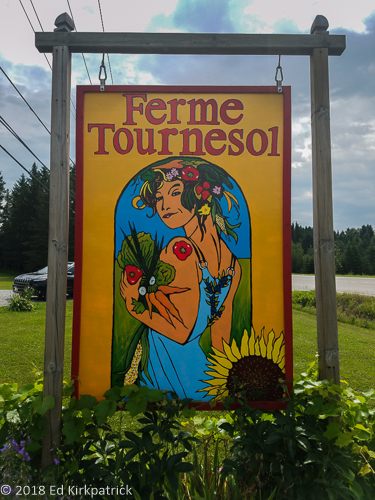
Not feeling like doing cities we passed Saguenay and were soon into pretty farm country where we stopped at a wonderful farm market, Ferme Tournesol.
Marti says she never looked like this after picking veggies out of our garden.

We didn’t buy nearly enough from these folks. The produce was just beautiful.

Yum!
Driving through Dolbeau-Mistassini we spotted a wonderful chute (waterfall) where RV’s were clearly camped and Ed immediately turned down the road. Being a Saturday, in a town, I was not expecting to get a spot, but the nice man said yes he had 3 sites and we should select which one we wanted 🙂

We think we just happened to get the best site in the park.

The Chutes
We continued north taking RT167 and then RT113 to Camping Opemiska where we stopped for the night and next morning headed toward TCH 117 (Trans Canada Highway) and Val-d’Or.

All across the northern parts of Quebec, the roadside wildflowers were a riot of color and especially the Loosestrife, Pearly Everlasting and Goldenrod interspersed with lots of Cattails.

Of course, there are lakes everywhere.

and Birch trees many of which grow to over 100 feet tall in dense groves.
I will be honest and admit this entire trek across Quebec has been unplanned and completely “by the seat of our pants” traveling. A lot of it was as Ed says, “just so we can say we’ve been there” and while I am looking forward to seeing Thunder Bay, Ontario where I actually have looked for things to do, we do have one more “just so we can say we’ve been there” on our horizon before that. 🙂

Looking towards the bow and what Ed thought was Baie-Comeau but turned out to be Godbout.

We waited for several minutes behind this truck with possibly the largest pipe we have ever seen on the road for a single lane traffic light at a construction zone. There is lots of construction on these roads because they only have about three months to make all the repairs and improvements due to the heavy trucks that tear them apart as well as the harsh weather.

North of Manic 2 on RT 389 when the Sun came out.

The lighthouse at Cap-de-Bon-Desir.

Carrots! More beautiful produce at Ferme Tournesol.

Crackerberry or Creeping Dogwood, (Cornus canadensis) and Indian Pipe.

Guess what else is growing wild in profusion and is ripe for the picking? Bleuets! Oh yum!

Turns out to our great amazement not only do they mine iron ore up here but gold. At Malartic, Quebec this pit mine is the largest open-pit gold mine in Canada. The pit measures 1.34 miles across in the long dimension and a half mile across. We only know this because of the biggest pile of tailings we have ever seen anywhere. The current vein they are mining is estimated to contain 9 million ounces of gold and it’s only one mine. Think about that.
We are currently in Ontario on Lake Superior and will keep you posted soon!
As always, thanks for coming along!


Wonderful post Marti and Ed. Thank you for sharing, as always. Makes me wish John and I were there.
LikeLike
Oh my gosh the pictures are amazing!
Rip-rap must be a dock material term?
Love y’all!
Bug
LikeLike
Wonderful!
LikeLike