
Tags
Dr. Grenfel, Dr. Grenfell, Fog, Fossils, Gros Morne National Park, Icebergs, L'Anse aux Meadows, Lighthouses, Lightkeepers Seafood Restaurant, Newfoundland, Port au Choix, SS Ethie, St. Anthony, Vikings, Whales
Newfoundland (newfun LAND) is an island and when driving an RV to an island the only way to get to it is via ferry, so we reserved a spot online. Following the instructions to be there an hour before boarding, actually we made a point of being early, we arrived at the dock in North Sydney, Nova Scotia and were sent to lane 11 to queue up and wait our turn to drive onto the MV Blue Puttees bound for Channel-Port aux Basques, Newfoundland.

Waiting in queue as the 18 wheelers are loaded on to the MV Blue Puttees. The vessel is named in honor of the Newfoundland Armed Forces in WWI who were nicknamed the Blue Puttees for the blue leggings (puttees) they wore over their boots.
After the 6 ½ hour crossing we off-loaded and headed straight for the nearest campground JT Cheeseman Provincial Park where the sites are huge, private, with electric only but on both sides of the space and at least when we were there pretty much empty! For you fellow RVers, the drinking water spigots all said boil before using, so we just didn’t use it.
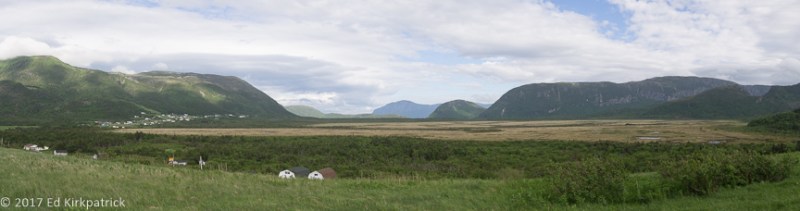
The Long Range Mountains run up the entire Northern Peninsula and are an extension of the Appalachians.
We had decided to head for the Northern Peninsula and L’Anse aux Meadows first, so taking the TCH (Trans Canada Highway) to Corner Brook we picked up 450 driving out almost to the end of the road and Blow Me Down Provincial Park. The water here also required boiling. Before getting there however we stopped at the Blow Me Down Nature Trail between Frenchman’s Cove and York Harbour. A good distance from the parking lot is a lovely tall waterfall which doesn’t seem accessible but there is a trail that wonders off through the bog ending at what we’d call a river but the local kids we chatted with call a brook! We stayed there only long enough to get a photo as the blackflies were swarming near the water.
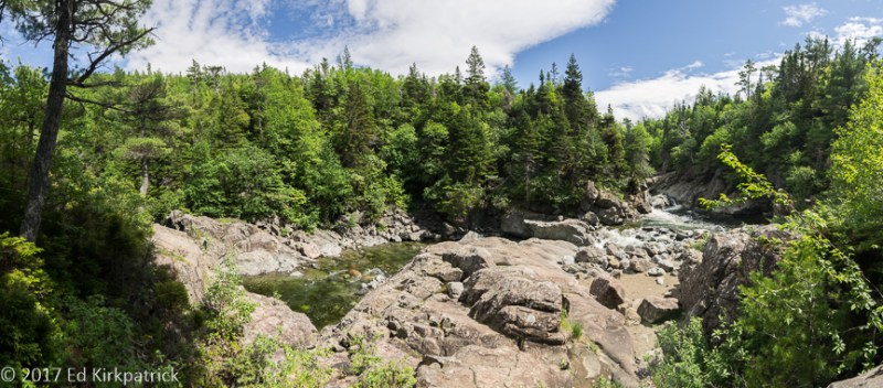
This is a very popular local swimming hole and we passed lots of young people coming back, some wet, some not. The water is cold snow melt. You can’t see the blackflies, but trust us, they are there.
The next morning the weather was not in our favor, but very typical for Newfoundland, VERY low clouds/fog and misty.
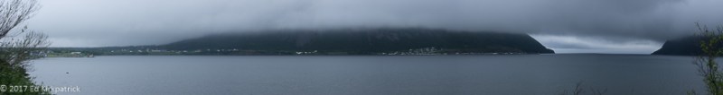
Just a little fog…
The route up the Northern Peninsula is 430 running right along the coast. There’s a lot of construction on the first bit but one has to remember that with the winters here there’s a very small window to do any type of construction/repair work. It was to our advantage actually because there wasn’t a lot of traffic and our short waits gave us a chance to look around before moving on up the road.

We could see the beautiful landscape even with the coming and going of the fog.
We stopped at the site of the 1919 wreck of the SS Ethie. All crewmen and passengers were saved, including a baby that was transferred safely in a mailbag to waiting hands on shore but the ship lost.

Rusting bits are all that’s left of the SS Ethie.
We arrived at Port au Choix (Port ah Shuwwaaa) as the sky was clearing and checked into the Oceanside RV Park run by the United Towns Lions Club. Situated right on the shore and with electric, water and wifi this is a no frills but wonderful location! After picking our spot and marking it we headed into town. Basque whalers in the 16thth century fished here and gave it the name Portuchoa meaning “little port”.
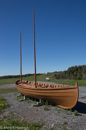
The Chaloupe, a vessel of Basque origins was used for hunting whales and fishing cod in the 16th century. In Newfoundland, they have long disappeared. The knowledge to construct them is still in use in Basque country in Spain, so in 2004 an association of Basque Maritime Heritage came over and three boats were built. This is one of them.
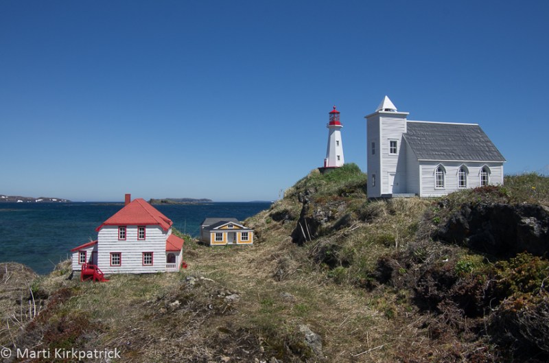
Later this area was part of the “French Shore” given to France as exclusive fishing rights, but not as land for settlement, in the 1713 Treaty of Utrecht, and hence the French version of the name which translates to Port of Choice. We stopped for dinner at Anchor Café where we not only had excellent fish chowder and really good pan fried cod, our friendly and fun waitress Norvalee told us about Pointe Riche Lighthouse.
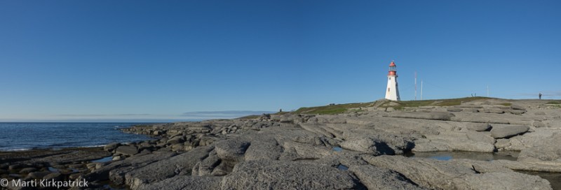
The wooden “pepperpot” style Pointe Riche Lighthouse in Port au Choix built in 1892 to replace an earlier light.
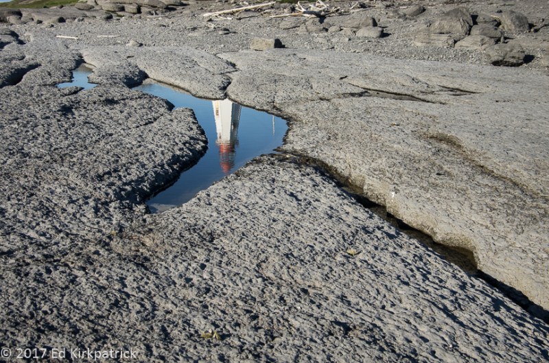
Back at the campsite we walked around the huge, flat rocks that are the shore and discovered they are covered with fossils! All in all, put Port au Choix on your MVL (Must Visit List).

One of hundreds of fossils we saw in the rocks of Port au Choix. Ed thinks it is a bill of a swordfish-like billfish. Marti is waiting for an expert’s opinion.
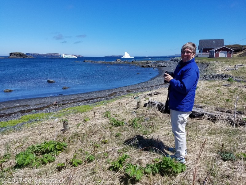
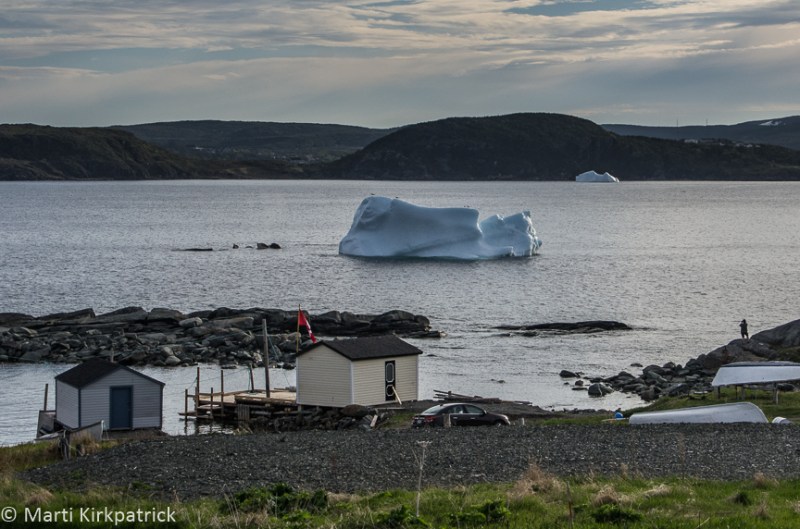
The next day was just plain ugly weather wise, and not much better the following day, but we headed on north anyway towards Eddie’s Cove where we saw our first iceberg!

It’s easy to get excited when it’s your very first iceberg. Marti was very thrilled. Little did we know what was coming up North. This size is called a Growler.
At this point the road turns east inland where the fog and rain slowly faded away, then up to the northern tip of Newfoundland, splitting into four fingers of road. We drove up 437 to Cape Onion where we saw more and bigger icebergs.
She’s a Happy Camper at Cape Onion the northernmost point in Newfoundland.
Then back down and out 436 to Quirpon and Viking RV Park where we settled in for the night.
To our great relief we woke to find the beautiful sunshine had remained and we quickly headed on up 436 to L’Anse aux Meadows a place that I was very excited to see. Discovered in 1960 when Helge Ingstad and Anne Stine came to this area following their study of the Norse Sagas. They asked the village residents if they knew of any mounds or unusual shapes in the surrounding landscape. Local George Decker took them to an area they all called the “old Indian camp”. Excavations began and with the discovery of an unquestionably Norse made cloak pin the first European settlement in North America was confirmed, dating from 1,000 years ago!

L’Anse aux Meadows National Park. The boardwalk leads you through the settlement excavation site over to the recreated village. Once excavated and documented the sites were covered back up with dirt to preserve their integrity for future study but the outlines of the building foundations are quite clear.

…as you can see. Yes, that is snow on the hillside.
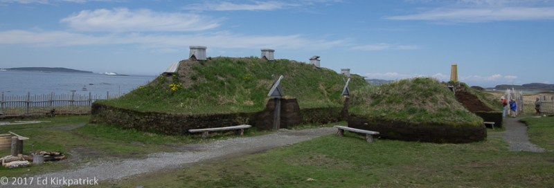
Walls constructed of peat are based on the foundation excavations, the roof design is taken from known styles recorded in Iceland. They are very substantial and on this nice day pretty cozy feeling.
Back down the south arm of 430 we went to St. Anthony where we discovered Lightkeepers Seafood Restaurant. Put this on your MVL! We had lunch here twice and even stayed an extra day to try their dinner menu!

Located on Fishing Point, the Fox Point lightkeeper’s home is now a restaurant.

Amazing Seafood Chowder, the best yet for lunch one day and Cod Tongues for dinner appetizers the next. The Cod Tongues tasted OK but had a chewy texture. BTW, they’re not really tongues but a muscle from the cheek. Did we mention the Iceberg Beer… oh, oh, oh and Moose Sliders. Yum!
There is a gift shop and museum across the way as well and we had a wonderful time chatting with the owner as well as purchasing some of his mother’s homemade jams. On one of our visits I also walked the short trail behind the restaurant where a large white X was painted on a rock.

Do you see it?
Turns out the “X Marks the Spot” where on August 10, 2009 Francis Patey threw his 2 page message about his hometown, inserted into a plastic soda bottle, into the ocean. For 544 days it traveled along an unknown journey until being spotted and picked up on a Brittany, France beach by Joy Nash! Francis had included his contact information and Joy did just that! FUN!!
We visited the Grenfell Center where we learned about the amazing Dr. Wilfred Thomason Grenfell who in the late 19th and early 20th centuries fell in love with Newfoundland and Labrador and spent the rest of his life, along with his wife, doctoring, educating and supporting the peoples in these two incredibly remote and difficult environments by building hospitals and schools.
We sat and watched on a foggy wet Sunday as men worked at the end of a newly constructed rock pier doing something in the waters of St. Anthony harbour. Watching through binoculars, I asked Ed “What do you think that yellow broken tube thing is?” one of the guys had taken out of a box, my clever husband says “Dynamite, that’s what they were doing, they’re going to blast under the water!”

Boooooom! Only when under the water it wasn’t much of a shock but lots and lots of bubbles. The drilling rig is shown on the right side of the photo. A platform on the end of a long arm attached to a tracked vehicle. They are blasting away a huge rock shoal to make the harbor deeper for container and cruise ships. Good for the local economy but we are afraid it might destroy the charm of this small town.
Newfoundlanders call their island “The Rock” and true there is precious little soil on it, but we are having a wonderful time and hope you are enjoying our window into this beautiful place. There’s a lot more to come and we can’t wait!
Bottle Cove at the end of 450 near our campground at Blow Me Down Provincial Park.

Pointe Riche Lighthouse.
Pointe Riche Lighthouse, again…

June 25th, and almost 11PM this far north and it’s still very light in the western sky. This is from our campground in Port au Choix.

There are small cemeteries all over Newfoundland. We think it’s because they are by denomination and most villages have at least two churches each with its own burial ground rather than community cemetery like at home.
A small tableau on a hummock in Cape Onion. We have no idea who built it but it sure is cute and real looking.
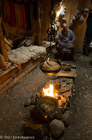
The interior of the big house at L’Anse aux Meadows is fully outfitted with reenactors who answer your questions and perform the daily duties of life in the year 1000AD.
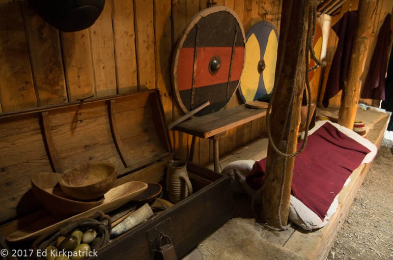
Some of the accoutrements of daily Norse life. We are told they are only Viking if they are off killing and pillaging. 🙂

Detail of an entrance and the sod construction. They cut the peat four miles away so as not to disturb the integrity of the site. The walls are three feet thick.
We saw what we think are Minke (minky) whales feeding in the bay of St. Anthony Bight. These are the only whales we have seen because as we have been told, the capelin are still out at sea and the whales are there feeding on them. There is no cod inshore yet either for the same reason. The local fishermen are getting very restless.

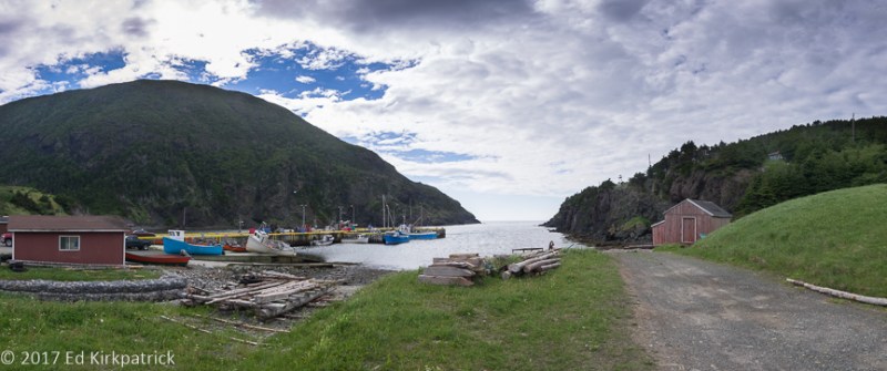
Evening at the harbor of St. Carols, near St. Anthony.

Marti went for a walk after dinner at the Lightkeepers. Fog, as usual is coming and going which makes for beautiful light, sometimes.

Ed looking very Viking-like. Kevin says, “Keep your shield up or I’ll ring your bell Dad!” For those who don’t know, our son Kevin was a member of the Society for Creative Anachronism and participated in the Pennsic Wars as a teenager.


Thank you for sharing Part One. You are having some fun adventures and missing the 90 degree + weather here. We escaped to Shenandoah N.P. Last week and will be leaving for Niagara on the Lake for the Shaw Festival on Aug.5-11. The walking group was small this a.m. (Seth, Ken, and I). I rode the bike and Seth kept up with Ken’s run so they were able to talk! Continue to enjoy Newfoundland. The people sound wonderful! Margaret Sent from my iPad
>
LikeLiked by 1 person
Hey Margaret, thank you! Glad that at least Seth made it out today, and what a treat that Ken had someone to chat with 😉
LikeLike
Ed and Marti, You might remember me as a good friend of Sharon Mason. I have Ed’s pinhole photograph of Gallery West which is in my hallway that I call “Gallery West” here in Placitas, NM. Besides your photo, I have work by my daughter and some from local artists. I am enjoying reading about your trip and follow up on Google Earth. Would love to be on the open road, too. Looking forward to the next part of your journey.
LikeLike
Thank you Dawn, we do remember you and are so happy you are following along! We have enjoyed occasionally hearing from folks whom we remember when…..
LikeLike
Great story, we loved newfoundland. I will following you. Thanks for charing
LikeLike
Thank you Nelleke! Isn’t it a wonderful place!
LikeLike
Beautiful! Thanks for sharing to Newfoundland Iceberg Reports fb group. I look forward to Part Two!
LikeLiked by 1 person
Thank you Diane, we’re so pleased you enjoyed it! ICEBERGS….just TOO COOL!
LikeLike
Looks like a beautiful and amazing place!
LikeLike
You and Wayne would have so much fun photographing here!
LikeLike
Love the pictures and commentary as always.
Love,
BooBoo and Mike
LikeLike
Thanks Clare! So happy you are reading them all!!! We appreciate it very much!
LikeLike
ed and marti…just wanted to say that i ***SO** look firward to your updates…such a joy to vicariously enjoy all you’re experiencing and seeing; travelogue and images just superb…you have material for a very special book one day! thank you again for such a gift you give to your readers! 🙂
Sent from my iPhone
>
LikeLike
Thank you SO MUCH Andy! …of course the other thing is your wonderful black & white images which could easily be their own book!
LikeLike
Wow! Just Wow! What a glorious place to be, and obviously, you’re enjoying every minute. I’m following your journey. Thanks for taking us all along.
LikeLiked by 1 person
Thanks Cheryl! You and Ron should come on up!
LikeLike
Enjoyed your blog. We are heading to the Northern Peninsula on Wednesday and will try to follow your recommendations for campgrounds and restaurants. Thanks!
LikeLike
Sure hope you enjoy these places as much as we did. It is a beautiful place!!
LikeLike
Oh my, I certainly enjoyed reading your adventures!! I am originally from St . John’s Newfoundland and have been living in Florida for 30 years! I have never been to the Northern Peninsula and it’s amazing seeing it through your eyes!! It’s true when people say “you don’t know what you have until you’re away from it”. I long to go “home” again and travel the island to see what I missed growing up there. Can hardly wait for you next installment! Thank you so very much for sharing this with us!!
LikeLike
We have not made it down to St. John’s yet but are slowly on our way! We are so delighted that Newfie’s have enjoyed our post about your wonderful home!
LikeLike
That Ed looks ten times more “Viking-esque” than the interpreters at the L’Anse aux Meadows site! I am surprised they didn’t offer him a job. 😉
Love following in your footsteps!
Suzanne
LikeLike
Ha Ha Suzanne!! Thanks for reading!
LikeLike
Glad you discovered my Island, it is like no other. Great pictures, keep them coming
LikeLike
Thank you Carol! We, too are glad to discover your home. It has been a long time on my list of places to visit and we think it is just beautiful. Also, thank you for enjoying our blog, there is lots more to come.
LikeLike
Pingback: Newfoundland ~ Part Deux, Gros Morne | Whack-A-Mole Wheels
Cod tongues are indeed tongues and not cheeks. A cod tongue consists of the actual tongue which is of a jelly-like consistence attached to the more muscular, chewy piece which is the bottom of the mouth. Cheeks are the meaty part of the cheeks of the cod, a similar texture to the meaty part of the tongue. I hope this makes sense! If they were chewy, they may have been over cooked. I’ve read all of your blog posts about your trip to Newfoundland and have thoroughly enjoyed them! Hope you don’t mind if I share the link with my sister who is helping a friend plan a trip to the island in 2018!
LikeLike
Thank you, Sally Ann! We heard both descriptions of cod tongues while we were on the island. We both agreed that once was enough though regardless of which piece they were. I know what you mean by the cheeks because I actually ate that little bit of flesh raw when we were cleaning some cod we caught but that’s the next post… lol. As for sharing, please share away! and follow us for further adventures this Fall and Winter.
Ed
LikeLike