• About

Whack-A-Mole Wheels

Whack-A-Mole Wheels

Tag Archives: Death Valley

Death Valley ~ Part Three

08 Tuesday Mar 2016

Posted by Ed and Marti Kirkpatrick in Bushes and Blooms, Travels

≈ 5 Comments

Tags

California, Death Valley, Desert Gold, Emigrant Canyon, Furnace Creek, Kit Fox Hills, Titus Canyon

This final posting on our wonderful visit to the remarkable Death Valley is a collection of Ed’s photographs mostly from our last day there.   We had a terrific time and will get back someday hopefully with a jeep, stronger legs and reopened roads!  If at all possible, please put Death Valley National Park on your Must Visit List.  Oh and if you do, I suggest An Introduction to the Geology of Death Valley by Michael Collier as a very informative read.  You can pick it up at the visitor center in Furnace Creek.


20160127-_EKP5813-Pano

Just off the road to Scotty’s Castle are the Kit Fox Hills in the Grapevine Mountains.

20160128-_EKP5947

Desert Gold, you cannot help but smile when you see these flowers and since we were there,  there has been a massive bloom of them.

20160125-_EKP5546-Pano

Evening along Badwater Road.

20160117-_EKP5298

This guy and his buddy were entirely too friendly and healthy for wild animals.  The tourists must be feeding them.

20160128-_EKP5982

Titus Canyon meanders through some very ancient rock formations.  Here, the sunlight reflects off the mountains beautifully lighting this face.

20160128-_EKP5978

Titus Canyon in the Grapevine Mountains.  Although the mountain range was geologically speaking uplifted quite recently most of the rocks that make up the range are over half a billion years old. This road runs 24 miles one-way from Rhyolite, Nevada to the exit in Death Valley, California.  From there we hiked back up the road about two miles.

20160128-_EKP5965

A formation of Megabreccia or the Jigsaw as it is known locally.

20160128-_EKP5992

Travertine (Ed is pretty sure but invites comment from someone who knows better).  There was lots of it in Titus Canyon.

20160128-_EKP5967

In Titus Canyon, fractured quartz  with a reddish/pink mineral (feldspar?) intrusion that gives it this pattern.  This piece is about the size of a soccer ball.

20160130-_EKP6093

Mysterious pot-holes in the floor of Panamint Valley.

20160117-_EKP5307
20160117-_EKP5254

Desert Sand Verbena, L                        Brown-eyed Evening Primrose, R

20160117-_EKP5314-Pano

A spreading bloom of Desert Gold paints the alluvial fan of the Black Mountains near Ashford Mill.

20160128-_EKP6021

Marti climbed up to an abandoned mine to see what she could see and took this photo looking back at our rig on Emigrant Canyon Road in the Panamint Mountain Range.

20160128-_EKP6019

Here’s the mine.  She really wanted to go in but promised she wouldn’t.

20160128-_EKP6007-Pano

Looking south across the Panamint mountains to Telescope Peak, 11,049 feet.

20160128-_EKP6010

At the top of Emigrant Canyon in the pass elevation 5318 feet.

20160128-_EKP6042-Pano

HWY 190 looking east back down eight miles to Stovepipe Wells from Emigrant Canyon Road.

20160128-_EKP6052-Pano

On our way back to our campsite at Furnace Creek and it’s almost cocktail time…


Death Valley ~ Part Two

27 Saturday Feb 2016

Posted by Ed and Marti Kirkpatrick in Travels

≈ 8 Comments

Tags

California, Death Valley, Furnace Creek, Harmony Borax Works, Mesquite Flat Sand Dunes, Twenty Mule Teams, Ubehebe Crater

As promised, part two of our visit to beautiful Death Valley documented with Ed’s wonderful photos of this unique landscape.

Harmony Borax Works

Borax was discovered near Furnace Creek in 1881 and by 1884 the Harmony Borax Works was processing the ore.  The greatest obstacle to this venture was the 165 mile distance to Mojave, the nearest railhead.  Wagons weighing 7,800 pounds empty were constructed to haul the ore.  A “train” of two of these wagons plus a metal water tank where hitched to a team of 18 mules and 2 horses.  When loaded it weighed in at 73,200 lbs, (36.5 tons) and it took ten days to haul the ore from the mine to the rail yard.  Although only operating for 6 years, the 20 Mule Team is still Death Valley’s most famous symbol.

20160126-_EKP5640

The two wagons and the water tank pulled by the twenty mule teams.

20160126-20160126_131700

At Furnace Creek there is a wonderful little museum all about Death Valley and the people who lived and died here.  This borax wagon wheel is seven feet high and the iron tire is six inches wide.

Salt Creek

A .8 mile boardwalk loop which affords an up close look at pickleweed and salt grass growing in  the salt marsh and along Salt Creek, which is also the only home to the Salt Creek Pupfish.

20160127-_EKP5791-Pano

There IS water in Death Valley and Salt Creek is proof of that.  However it is so salty precious little, animal or plant can survive in it or near it. 

20160127-_EKP5805

Salt Creek Pupfish can and do survive even though some summers there is only a small bit of water left after evaporating in the heat.

20160127-_EKP5802

Pickleweed thrives in this salty soil.

20160127-_EKP5796

A harsh place but the sound of streams is nice and the same anywhere.

Devil’s Corn Field

Near the Mesquite Flat Dunes, Devil’s Corn Field is a flat plain covered with large clumps of salt tolerant Arrowweed.  Catching and holding windblown sand at their base, these tall straight stalked grasses look very much like sheaves of harvested corn.

20160127-_EKP5811-Pano

Mesquite Flat Dunes

20160128-_EKP5994-Pano

The best known and most easily accessible sand dunes in Death Valley, Mesquite Flat Sand Dunes while not particularly high, the tallest is 100 feet, they do cover a vast area.

Ubehebe Crater

The Ubehebe (YOO-bee-HEE-bee) Crater and the smaller Little Hebe Crater and several other small craters in the area, are known as Maar volcanos.  They are created when hot magna rising through a fault flashes ground water into steam which expands with incredible pressure releasing in a tremendous explosion called a hydrovolcanic eruption.

20160127-_EKP5840-Pano

Ubehebe Crater is over a half mile wide and 400 feet deep.

20160127-_EKP5855

You should have heard Marti saying, “Edward!” as I kept inching closer to this 400 foot tumble.

20160127-_EKP5857-Pano

We circumnavigated the larger Ubehebe and a small unnamed crater next to it and in front of Little Hebe crater.

20160127-_EKP5899

Little Hebe has the distinction of its entire rim being intact thus indicating it may be the youngest crater.

20160127-_EKP5892-Pano

From Little Hebe looking back to Ubehebe note our RV there on the far left edge for scale.

20160127-_EKP5922

I be, you be, we be at Ubehebe Crater!  Note again the RV a half mile away across the crater.

20160127-_EKP5931

This raven and his missus followed us nearly all the way around the crater until they realized there was no treats coming and another carload of tourists pulled into the parking lot.  Off they went. At one point we watched him dig up an anthill and eat ants. Yummers.

NOTE: Several postings ago I mentioned more research needed to be done about the bones we found in Banshee Canyon at Hole In The Wall.  I did more investigating and we are now 99% sure the bones and certainly the two skulls are Harris Antelope Squirrels which we also saw playing on the rocks there. That being the case, the feasting almost had to be by owls.  Hawks might also partake, but we believe owls would be more likely to live in the holes in the rock walls.

The third and last photo collection of Death Valley is coming real soon!


Death Valley ~ Amazing!

20 Saturday Feb 2016

Posted by Ed and Marti Kirkpatrick in Travels

≈ 9 Comments

Tags

Artists Drive, Badwater Basin, California, Dantes View, Death Valley, Desert, Devils Golf Course

During the summer of 1962 my Dad loaded us up in the station wagon for a sightseeing trip across country.  Among the many places he took us was the desert southwest where he had worked in the 1930s and he and Mom started their married life.  The idea of a place called Death Valley fascinated me and I wanted to go see, but my father said no, there was nothing there worth seeing.   Sorry Dad but WOW you were SOOOO wrong!  In fact, now that Ed and I have been to Death Valley, it is solidly on my top 5 favorite places list!

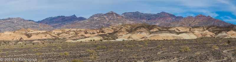
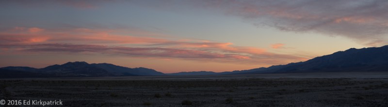
Covering over 3.3 million acres Death Valley is a place of extremes.  Bordered on the west by the Panamint Range, the highest peak being Telescope at 11,049 ft. and on the east by the Amargosa Range made up of the Grapevine, Funeral and Black Mountains, nearly 550 square miles of the Death Valley basin is below sea level.  In fact at 282 ft below sea level, Badwater Basin is the lowest elevation in North America and the 8th lowest in the world.  It is this valley depth, steep mountain height and relatively narrow shape of the basin that influences the temperatures where HOT does not begin to describe it.

As we all know warm air rises and cool falls.  Here at these extreme low elevations as the soil and rock get very hot and as this hot air rises back from the heated surface it is trapped by the mountain walls and only cooled slightly more than the air temperature. Then this descending air is compressed and heated even more due to the low elevation air pressure. This super heated air cycles though the valley as the ground temperature climbs ever higher adding “fuel to the fire” so to speak. 🙂  The highest temperature in the world was recorded here on July 10, 1913 at a whopping 134°, (disputed by some weather historians, they do still claim Death Valley has the highest temperature ever reliably recorded) and that’s just air temperature.  The highest ground temperature is an incredible 201°!

NOTE:  Perhaps Dad was right to not bring his family here during the month of August 🙂

There are four major mountain ranges between the Pacific and Death Valley, each depleting the amount of rain-fall advancing eastward.  These rainshadows cumulatively rob pretty much all the moisture before it can fall here, consequently the average rain for an entire year is only 1.94 inches!  Last October however there were back to back storms followed then on the 18th by an incredible storm where 2.7 inches of rain fall in just five hours!  From the Los Angeles Times news article, Death Valley District Ranger Paul Forward, trapped near Grapevine Canyon and Scotty’s Castle, “It started with heavy hail,” he recalled. “Three hours later, the dry wash was transformed into floodwaters 100 feet wide with 20 foot waves. The air was filled with the sounds of massive boulders grinding against each other as they rolled down the canyon.”

This 1,000 year flood destroyed roads and caused extensive damage that will take perhaps two years to repair.   Consequently, there are a number of places now closed to visitors.  There are also a number of places where we would have liked to have gone, but they are only accessible by high clearance and/or 4 wheel drive vehicles.  Even so, over five days we had a fabulous time exploring.
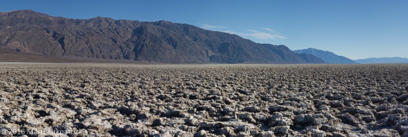
Badwater Basin

All the rain that falls on the surrounding mountains and the valley carries with it dissolved minerals and salts which can not flow out because Death Valley is an enclosed basin.  Badwater, being the lowest place in the valley, is where all this mineral rich water flows to and evaporates leaving behind this layer of salt.

Badwater-1

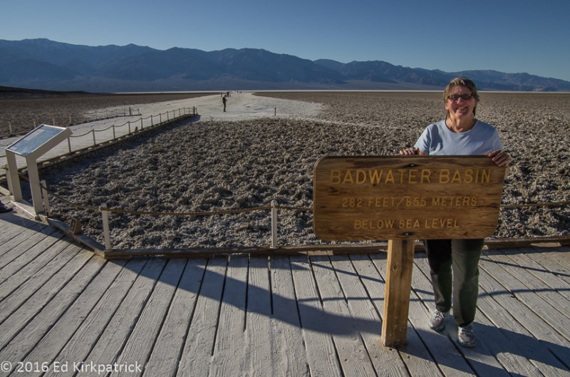
282 feet BELOW sea level.

Badwater-2

The pool comes and goes.  Look carefully at the red arrow to see the big sign on the mountain side that marks sea level.

Badwater-4

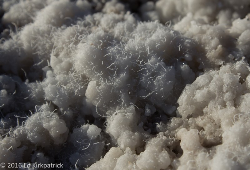
The salt layer is quite thin and the crystals are constantly growing and changing.   Most of the salt is sodium chloride (table salt). Calcite, gypsum and borax make up the remainder.  The crystals are constantly changing with rainfall and evaporation and the tiny hairlike crystals are shaped by the winds as they grow.

Badwater-3

We were there.

Devil’s Golf Course

Devil’s Golf Course is several feet higher than Badwater Basin and consequently it stays dry which allows the weathering processes of wind and rain to sculpt the salts, minerals and mud into a crazy landscape of rough, complicated and beautiful formations.

Devils_Golf_Course-2

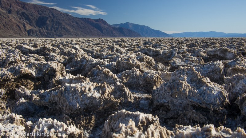
Devils Golf Course.  These formations vary from about six inches to knee high.

Devils_Golf_Course-1

Badwater Basin and Mormon Point are to the south of Devils Golf Course.

Devils_Golf_Course-4

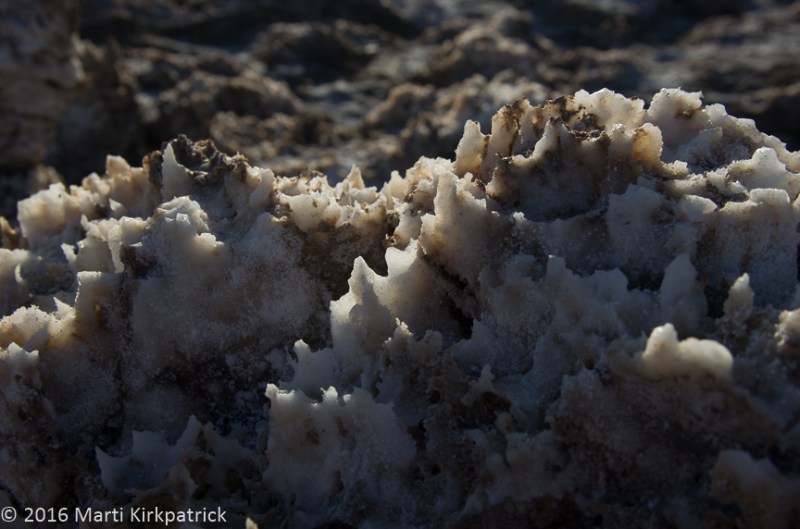
The salt spire’s edges are very sharp. Do not fall down in this place.

Dante’s View

Considered one of the most breathtaking views in the park, Dante’s View overlooks Badwater Basin 5757 feet below.

20160126-_EKP5619

Looking down on Badwater Basin and eight miles across the valley floor to the alluvial fans of the Panamint Range.

20160126-_EKP5607-Pano

Looking North towards Furnace Creek.

20160126-_EKP5628

and looking South. Note the salt pools which are green and can be quite deep.

20160126-_EKP5633

Looking back to Dante’s View (see the RV?) and beyond, the high point is Dante’s Peak. 

20160126-_EKP5626

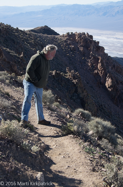
Contemplating the fall…  Hiking up to Dante’s Peak.

20160126-_EKP5605

Marti summits the peak!

Artist’s Drive

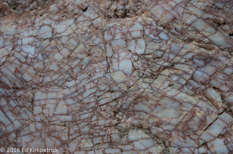
Artist’s Drive  is a nine mile loop drive back against the face of the Black Mountains noted for its astonishing variety of rock colors.  White, pink, green, yellow, mauve, purple, orange and browns, these colors are caused by the oxidation of the different metals in the rock.

Artist_Drive_-1

Heading up the alluvial fan of Artist’s Drive.

Artist_Drive_2

During very occasional rains over thousands of years, the water floods so forcefully down the mountains shooting over the cliff face carrying the stones and sediment away from the wall creating the piles of sand and rock.

Artist_Drive-4

The “Artist’s Palette” on Artist’s Drive.

Artist_Drive_-3

Looking back at the end of the drive.

Part Two of Death Valley is coming soon!


Enter your email address to follow this blog and receive notifications of new posts by email.

Join 221 other subscribers

View Recent Posts

  • Cod Jigging and New Friends! March 2, 2020
  • Grand Tetons ~ Yellowstone October 11, 2019
  • Beauty & Bones ~ Dinosaur National Monument September 29, 2019
  • Wyoming ~ In the Medicine Bow Corner September 25, 2019
  • A Bit of Western Nebraska September 5, 2019

Get Caught Up

Blogs We Follow

  • john pavlovitz
  • Take To The Highway
  • Kelly Time
  • HowToRVgeeks
  • WANDERTOPIA
  • BoomerCafe ... it's your place
  • Island Girl Walkabout
  • The Online Photographer
  • Technomadia
  • Wheeling It: Tales From a Nomadic Life

Categories

Blog Stats

  • 24,723 hits

Blog at WordPress.com.

john pavlovitz

Stuff That Needs To Be Said

Take To The Highway

Kelly Time

HowToRVgeeks

WANDERTOPIA

BoomerCafe ... it's your place

Island Girl Walkabout

Hector and Brenda on a journey of discovery

The Online Photographer

Technomadia

Adventures in Nomadic Serendipity

Wheeling It: Tales From a Nomadic Life

On the Road Since 2010, Traveling Across USA & Europe With Pets

  • Follow Following
    • Whack-A-Mole Wheels
    • Join 184 other followers
    • Already have a WordPress.com account? Log in now.
    • Whack-A-Mole Wheels
    • Customize
    • Follow Following
    • Sign up
    • Log in
    • Report this content
    • View site in Reader
    • Manage subscriptions
    • Collapse this bar
 

Loading Comments...