Utah ~ Scenic Byway 12, Burr Trail & the LDS

Tags

, , , , , , , ,

The US Department of Transportation, Federal Highway Administration lists Utah Route 12 as one of America’s Scenic Byways.   We had begun our traverse of the 124 mile long route with Bryce Canyon located at mile marker 13 (see the last post) and were now ready to continue on.

After Bryce, Route 12 slides in and out of Grand Staircase-Escalante National Monument.  We stopped at the Escalante Heritage Center which has an interesting display about not only the town of Escalante but the 1880 Mormon pioneer expedition from Escalante to Bluff, Utah referred to as the Hole in the Rock Expedition.

20180517-_EKP5843

This is a painting depicting the descent through Hole In The Rock that the Mormon pioneers blasted and built creating the gap that allowed them to continue on their way to Bluff, Utah. No one was lost. It was an incredible feat.

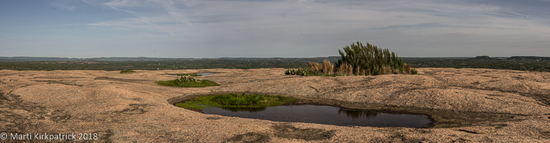
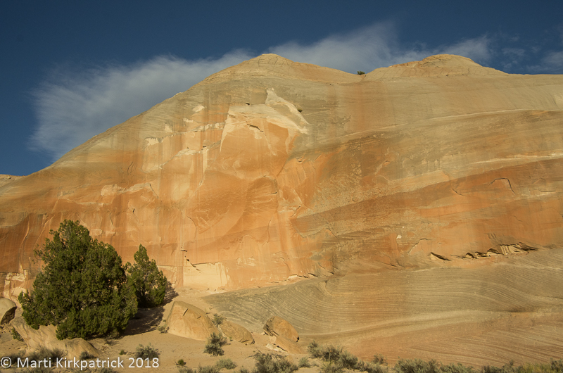
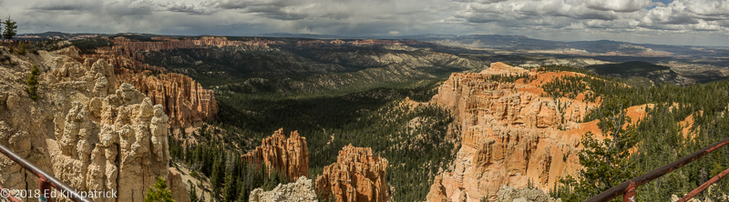
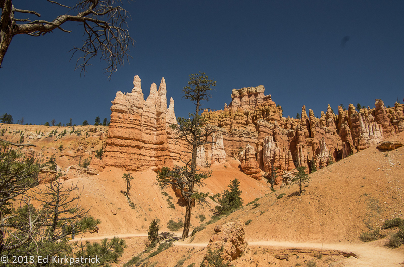
At mile marker 70 we stopped and marveled at the slick rock at Head of the Rocks Overlook.

20180517-_EKP5848-Pano

The term, slick rock is attributed to cowboys because shod horses hooves would slip on the bare rock and sometimes they would go down.  Crossing, particularly when wet, is very precarious whether on horseback or in a wagon.

20180517-_EKP5856-Pano

The CCC spent 5 years building a road through here parts of which are now RT. 12.  It’s known as the Million Dollar Highway because of the backbreaking labor and tons of dynamite used to blast through the slickrock terrain.

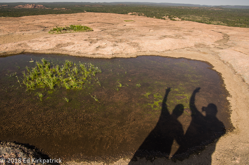
Just about five more miles down the road we stopped to enjoy the amazing views over the deep canyon of the Escalante River and a bit further on, down into Calf Creek where I hope to someday hike up to the falls.

20180517-_EKP5871

The trail Marti hopes to hike someday is visible in the bottom of the canyon.

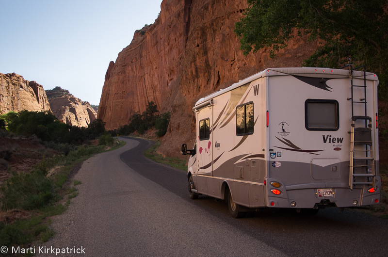
I had done my research as well as I could and assured Ed we could and should leave Scenic 12 and do the Burr Trail Road which crosses Grand Staircase-Escalante to Capitol Reef National Park.  So at Boulder (AKA  Boulder Town), we turned onto Burr Trail Rd where just a few miles in there was the 7 site BLM (Bureau of Land Management) Deer Creek Campground. Technically (according to their listing) we wouldn’t fit, but hey, it’s us so we “pushed and shoved” and JUST fit into spot #5 🙂

20180517-_EKP5897

The Moon and Venus delighted us that evening but the mosquitos soon drove us back inside. The creek was right behind us.

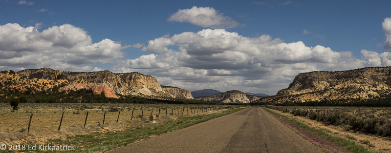
What a wonderful road!  Paved and basically empty of other vehicles Burr Trail Rd heads down through The Gulch into beautiful Long Canyon.

20180518-_EKP5905-Pano

Top of the Gulch headed down into Long Canyon on the Burr Trail road.

20180518-_EKP5940

Down inside the wonderful Long Canyon.

We saw an opening in the cliffs and stopped to walk back a short slot canyon.  Meeting a couple on the way out we were told it was called Singing Canyon which fit the effects we’d discovered already 🙂

20180518-_EKP5956

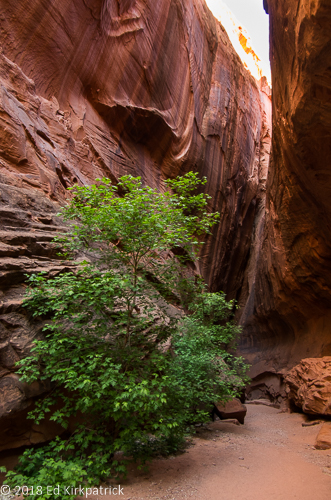
Headed back into the slot of Singing Canyon.

20180518-_EKP5965

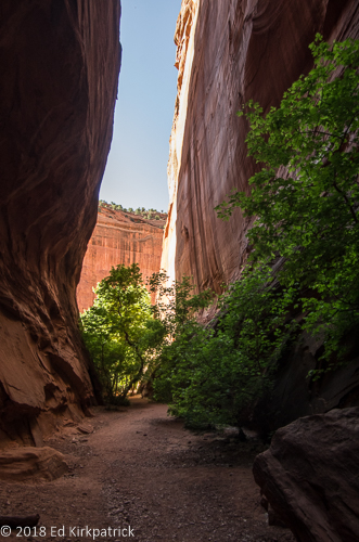
… looking back out to Long Canyon.  Ed had lots of fun chatting with the Goddess Echo.

20180518-_EKP6002-Pano

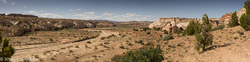
The landscape opens up outside of Long Canyon.

20180518-_EKP6039-Pano

The Henry Mountains and the Water Pocket Fold before them as we cross into Capitol Reef National Park where the Burr Trail road turns to dirt.


Coming out of the canyon it’s not much farther to the border between GS-ENM and CRNP where the pavement stops. The dirt road looked good and a nice Canadian couple we had chatted with the night before had said the entire road was fine, and well…it is us… so we continued on.

20180518-_EKP6067-Pano

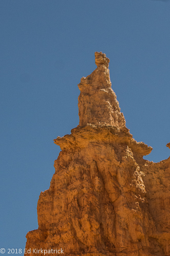
Today the hole in Peek-a-boo Rock is kept company by a sunspot of light.  🙂

20180518-_EKP6073

This should have been our first clue things were going to go downhill from here.

20180518-_EKP6084-Pano

800 feet down in just 1/2 a mile on slippery gravel and Marti had every confidence in Ed.  Of course, we didn’t know he had a detached retina in his right eye…  just knew that things were not as clear as they might have been.

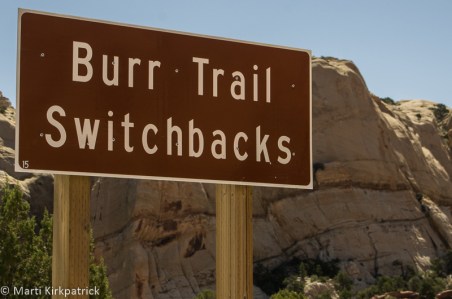
At the bottom of the Burr Trail Switchbacks, one can go left (Notom) or right (Bullfrog) on the Notom – Bullfrog Rd.  The Burr Trail continues right towards Bullfrog and Lake Powell and most folks actually go this way. We went left because the road would eventually take us to where we wanted to be for the night.  If one looks at the various websites both official and personal the road is “well maintained”, “only accessible by passenger cars”, “VERY rough”, “not recommended for RV’s”, and “impassable when wet”.

20180518-_EKP6113-Pano

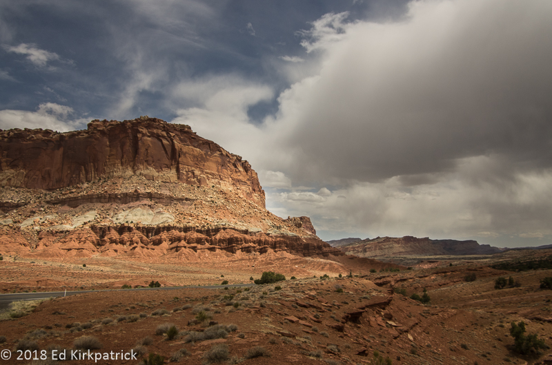
We had a spectacular day for this drive but as can so often happen…

20180518-_EKP6122

…the clouds suddenly appeared ominous from the West and the road was, to put it politely, crap.  Ed cursed the Canadian fellow many times but Marti thinks he was mistaken and had turned the other way to Bullfrog.  We still had over 30 miles to go.

20180518-_EKP6135

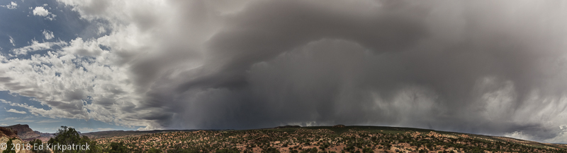
And the storm continued to build.  Marti kept wanting to stop.  Ed, remembering the “impassable when wet” part, was thinking about how much trouble we would be in if it actually started to rain.

Out of the backcountry of Notom Road and on Rt. 24 the RV campgrounds in the towns of Fruita and Torrey were full but a nice lady at one told us about tiny Sunglow Campground in the Fishlake National Forest a few miles further west near Bicknell.

20180518-_EKP6161

Sunglow Campground. We made it!

Happily, we did manage to get the nowhere near level, but very nice, second to the last spot.  The last spot was taken by a couple of delightful Dutch kids, Christine, a gastroenterologist and Jacob-Jan, a physicist. We really enjoyed talking with them over a couple of beers the two nights we were camped here.

Next morning we wanted to finish up the bit of the road we’d skipped doing the Burr Trail and so headed back towards Torrey and south on Scenic 12.

20180519-_EKP6162-Pano

Rt. 12 south heading for Boulder Mountain and the Dixie National Forest.

Here the road climbs Boulder Mountain in Dixie National Forest and because of the extra altitude, 9,606’ at the top of the road (the actual top is 11,313’) and the pine and aspen this area has an entirely different landscape…

20180519-_EKP6214-Pano

At the summit, the forest opens up and the view back to Boulder, Burr Trail Road and Long Canyon is spectacular. 

Bright and early the next morning we packed up and headed back down to Fruita and the visitor center.

20180518-_EKP6157

The Fluted Wall on Rt. 24 west of Fruita, Utah. 

This is the most known/visited part of Capitol Reel and from here we did the paved Scenic Drive.

20180520-_EKP6255-Pano

EPH Hanks Tower at the end of the paved road on Scenic Drive.

20180520-_EKP6259-Pano

This particular morning the clouds and approaching storm were almost more spectacular than the landscape.

20180520-_EKP6304-Pano

Scenic Drive in Capitol Reef National Park.

It was on this drive that Ed admitted his eye/vision was pretty bad and the better part of discretion was to head for Provo and Salt Lake City where there would be eye specialists.

20180520-_EKP6342-Pano

And that is what we did. Through the rain and the clouds across Utah on Rt. 89 to Provo.  Just an incredibly beautiful state. In fact, just put the entire state on your MVL, (Must Visit List).


20180517-_EKP5840

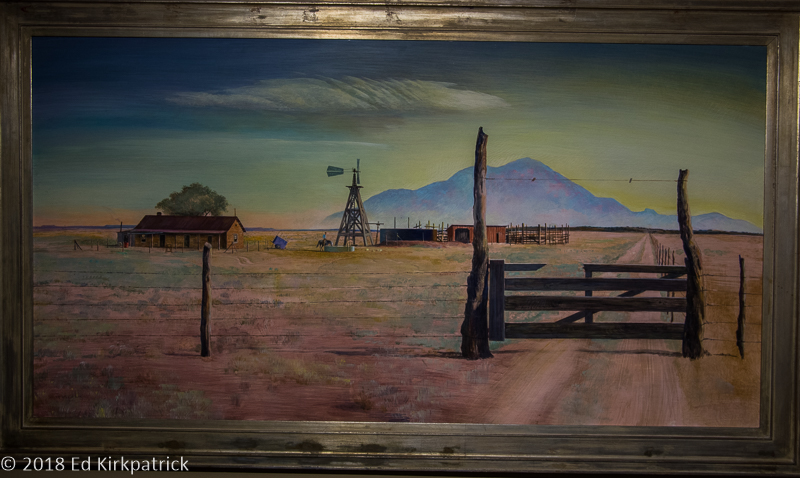
Inside a Mormon wagon.  Can you imagine traveling through this part of the world with this view?

20180517-_EKP5862

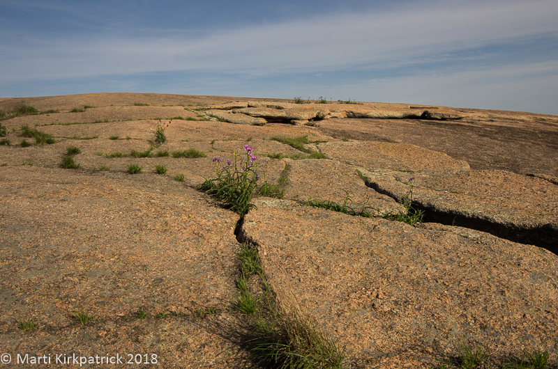
Scenic 12 outside of Escalante, Utah.

20180517-_EKP5877-Pano

Marti calls these green river snakes.

20180517-_EKP5887

The Hogback at MM80 on Scenic 12.  You will note the lack of shoulder or railing.

20180518-_EKP5974

Inside Long Canyon.

20180518-_EKP5983-Pano

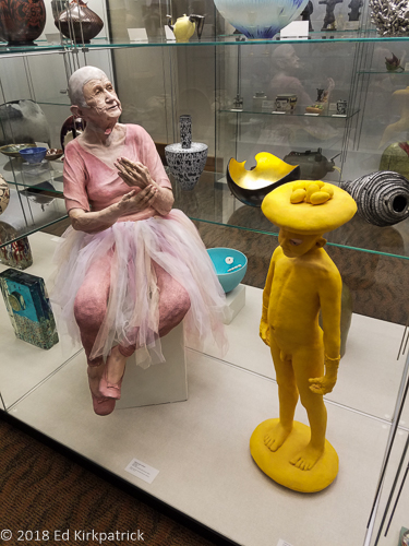
Geological canvas abstract painting.


20180519-_EKP6208

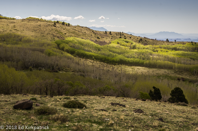
Notice how the aspens are at all different stages of leafing out. That’s because each grove is a single organism connected by roots underground and consequently each grove has its own timeline for waking up.

20180520-_EKP6324

Heading back up the Scenic Road to leave for Provo… It started raining just as we left the park and rained all the way across the state.

20180526-20180526_113456-Pano-2

After Ed’s eye surgery, we went up to Salt Lake City for two weeks. The streetcar stop was right outside the KOA so going in to Temple Square and city center was very easy.  This is the Mormon Temple reflected in the pool in the gardens.

20180531-20180531_194335

Thursday evenings the Mormon Tabernacle Choir’s rehearsal is free and open to the public.  We had a lovely dinner at Caffe Molise then walked over and thoroughly enjoyed this amazing choir.  Marti says if we lived here she would be here every Thursday.

20180526-20180526_140752

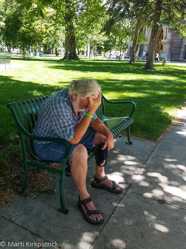
Not a headache.  Not disgusted, but under doctor’s orders to rest his eye by looking down for a while.  All in all, we really liked Salt Lake City not to mention beautiful Utah.  We will be back!


White House, Toadstools & Bryce Canyon ~ OR ~ You’ve Gotta Take a Walk

Tags

, , , , , , ,

As some of you know, not only were we home (Maryland) for almost a month, we’re now on the road again, New York and as of yesterday Vermont, heading for Canada.  Even so, Utah is just so magnificently beautiful and Ed’s photographic eye captures it so well, I still want to share our adventure and lots of pictures with you…   sooooo…

Leaving Wapatki Monument we headed north on US 89 toward Page and Lake Powell which we wrote about back in May of 2017.  We spent the night at the Page Lake Powell Campground where we’ve stayed before and tried to ignore the first really hot day we’d had pretty much this whole trip.

20180511-_EKP4931-Pano

The water level in Lake Powell is way down.

Utah’s Grand Staircase – Escalante National Monument begins just outside of Page and we had heard good things about the White House Trailhead Campground about 30 miles on up US 89.  Stopping in at the Paria Contact Station, the nice BLM (Bureau of Land Management) lady said we might have a little trouble with the last dip in the dirt road but there was a spot about 1 ¾ miles back where we could camp.  She doesn’t know us 🙂 We went the full 2 miles with no problem and being there early in the day had our choice of 4 of the 6 small sites; (there are also 5 walk-in tent sites beyond these sites).

20180511-_EKP4943-Pano

Whack-A-Mole Wheels camped at White House Trailhead, in Paria Canyon, Utah.

20180511-_EKP4982

The urRu/Mystics were watching over us. You will know the reference or you won’t. But here’s a clue – Dark Crystal.

20180512-_EKP5127-Pano

The Paria River “flows” down the canyon passed White House Trailhead.

20180512-_EKP5088

The wind creates beautiful leaf tracks in the sand and dust.

After our lovely 2 days at White House, we popped back south on US 89 a mile and a half to the Toadstools Trailhead where we did the short and easy hike back to see these fun rock formations.

20180513-_EKP5137

Toadstools, also known as Hoodoos, are formed when weathering removes the softer sandstone from around a harder sandstone cap.

20180513-_EKP5135

On the trail back to the toadstools, we discovered evidence in the sand of a pursuit of one type of critter by another more slithery type. 🙂

Bryce Canyon National Park was on our list back in the fall of 2016, but at 8,000 to 9,000 feet it was too cold when we were “in the neighborhood” so it was front and center on this Spring’s Utah adventure list.  As navigator, I directed Ed to continue on north along US 89 to Johnson Canyon Road which was supposed to be very pretty. The filming set for the old TV show “Gunsmoke” was also supposed to be on this road.

20180513-_EKP5189-Pano

The first part of Johnson Canyon Road which was quite beautiful and also paved… Then it becomes rough, washboarded dirt and the country is just flat and ugly.  As far as the Gunsmoke set, it’s on private property and was completely falling down and derelict. Oh, well…

Once out of the awfulness of the end of Johnson Canyon 89 is pretty and unlike the last time we were here the Sevier River had a lot of water in it.  Just shy of four miles down the righthand turn onto Rt 12 we were happy to find a not quite level spot at the first come, first served, Red Canyon Campground in the Dixie National Forest where with our America the Beautiful Senior Pass the price is $9 a night. We ended up staying 4 nights. 🙂

NOTE:  These America the Beautiful LIFETIME passes were only $10 when we bought ours a few years ago.  They have since gone up to $80 but even at that price if you do a lot of national parks, monuments and sites (a handful of states also recognize them) these passes are worth every cent.  Generally, they cut the price of admission either in half or FREE!

20180513-_EKP5213-Pano

Bryce Point at the furthest point on the road in the park is the start of a nice walk on the Bristlecone Pine Loop trail. There are shuttle buses that do a partial loop in the park.  In an RV when the shuttle is running you cannot stop at those spots so you need to take the shuttle.  However, there are many more viewpoints, including this one where you can park and get out to see the view or hike.

20180515-_EKP5549-Pano

Natural Bridge is one of the viewpoints where the shuttle bus does not stop.

20180515-_EKP5571-Pano

Piracy Point, another non-shuttle stop.


Just a couple of words about Bryce and then I will let Ed’s photographs and our comments tell the rest of the story.  First ~ Put this on your MVL (Must Visit List) but DO IT OFF SEASON!  It actually wasn’t too bad but we strongly suggest you start each day early to get a jump on the crowd.  We had a nice chat with one of the shuttle bus drivers when no one else was on board and he said in the last couple of years Utah is making a BIG push to attract tourists. They are pushing extra hard in Asia and Europe and judging from the myriad of languages we heard here (and in 2016 at Zion), they’re getting a huge response. He also said their visitor numbers are doubling every year lately!  Second ~ Stop at every overlook and look 🙂 . Third ~ Hike, a little or a lot, get out and walk at least some of the rim trail and down into the canyon.  Some folks claim it’s all the same but from subtle to radical it’s really all different!  Fourth ~ watch for the Violet-green Swallows.  They are beautiful. Ed tried to get a photo but they are too fast!   Mostly JUST GO!! 🙂


20180512-_EKP5031

Swallow nests made of mud from the Paria River at White House Canyon.

20180512-_EKP5044

Frank H. Clark, Sept. 25, 1911, left his mark on the wall at White House Trailhead.

20180512-_EKP5086

An old stile that was in a fence that is no longer here.  Someone ranched this area back in the day but no longer.

20180512-_EKP5090

The sandstone cliffs are what remains of ancient sand dunes and the lovely shapes and patterns are carved by wind and water.

20180512-_EKP5102

The swirls and ribbons left by different colored sand and dust blowing into dunes and over the ages metamorphosing into lovely sandstone cliffs.

20180512-_EKP5111

And then there’s the color of the cactus blooming amongst the sand dunes.

20180513-_EKP5146-Pano

Toadstools Trail.  Marti likes the white cliffs better than the toadstool formations.

20180513-_EKP5165

This speaks for itself.

20180513-_EKP5202

A roadside attraction while Johnson Canyon Road was still pretty.

20180515-_EKP5520

In Bryce Canyon, a Peregrine Falcon eyes Ed but decides better of it.

20180515-_EKP5545

Another vista at Bryce.

20180515-_EKP5589

A fire started by a lightning strike years ago leaves a scar but the forest always comes back.

20180515-_EKP5663-Pano

John’s Valley Road, a 60-mile side trip originates across from the Bryce Canyon entrance road. We decided we needed a break from all the red and orange rock and so headed north down Black Canyon towards the small town of Antimony. 

20180515-_EKP5661

The Osiris site at the base of Black Canyon is now an abandoned mill site.  

20180515-_EKP5681

Coming out of John’s Valley Rd, at Kingston and then onto Rt 89, look what we found! Butch Cassidy’s boyhood home.

20180516-_EKP5688

The next day we went for a hike down the Queen’s Garden Trail into the canyon.  Marti said it would be fun.  She failed to mention the last mile part…

20180516-_EKP5692

Heading down on the Queen’s Garden trail.

20180516-_EKP5703-Pano

… and down some more.  Why is everybody coming in the other direction?

20180516-_EKP5706

Ed found some shade.

20180516-_EKP5718

But, it does give you a whole new perspective.

20180516-_EKP5731

Still going down…

20180516-_EKP5749

And here’s Queen Victoria for whom the gardens are named.

20180516-_EKP5747

In case you didn’t see her in the photo above.

20180516-_EKP5766

Nearing the end of the down part is the shady part looking down into the valley and Marti’s gourmet lunch, granola bars, and water.

20180516-_EKP5784

The up part starts,

20180516-_EKP5791

and here’s the part Marti left out, 850ft. up over a mile of trail switchbacks.  The strategy was to go from shady spot to shady spot to get our breath.

20180516-_EKP5793

A view of Thor’s Hammer formation near the top.  It was pretty, Ed admits and worth the climb.

20180516-_EKP5809

looking back down the trail, you got to admit it’s spectacular.

20180516-_EKP5812

Goodbye from Bryce Canyon! We hope you can make it too someday.

Arizona ~ Old and New Favorite Places

Tags

, , , , , , , , ,

Hi there~ It has been many weeks since our last post but we have excuses 🙂 Our main plan for this summer’s adventure is what I have been calling the “middle bits”.  The areas of southern Utah: Bryce, Grand Staircase – Escalante, Capital Reef, Canyonlands, Arches, Moab and on north somewhere.  WELLLL… even though this post isn’t about any of those places, we have in fact done a bit of the above and there will be a post about that coming soon along with Ed’s wonderful photos.  The excuse for the delay is twofold. First, southern Utah is for all practical purposes off the grid (cell phones included) and we couldn’t do a post. And second, there’s the issue of Ed’s totally unexpected emergency detached retina eye surgery complete with a 2-week restriction on not only travel but reading and using his laptop!  So apologies for the delay and we hope you enjoy the below 🙂  Oh, and yes he’s doing well thank you!                                       *************************************************************

After a quiet night’s sleep at Black Jack Campground we headed on down Rt 78 which for a ways goes through some pretty mountain country

20180427-_EKP4474

78 outside of Blackjack and the forest.

but soon opens up and isn’t as nice. We picked up US 191 heading for Safford, (which is sorry to say downright ugly) and then onto Interstate 10.  We had planned to drop south to one of our favorite places, Bisbee, AZ  but when I phoned the campground in town they said they were completely booked.  Soooo we decided to head on to Oro Valley just north of Tucson and one of our other favorite spots, Catalina State Park, but when I phoned they also were full!  Our nonstop good luck seemed to be on hold, (it was Friday night and weekends are often busier) so we headed for Gilbert Ray Campground just west of Tucson where it’s first come first served and we hoped not full.

20180427-_EKP4496-Pano

Just behind our campsite at Gilbert Ray where it was not full, but in fact almost empty.  Over in front of those mountains is Old Tucson which was built to make movies and has only expanded and grown with many more movies and TV shows. You can take a tour but we didn’t.

20180427-_EKP4502

We took a short walk at Gilbert Ray to enjoy the cacti just coming into bloom.  This is a Cholla (choyya) a group of cactus that is perhaps Marti’s favorite.

Every time we’ve been in the Tucson area we’ve planned to go to the Pima Air & Space Museum not for the museum as much as the airplane boneyard.  This time, other than new tennis shoes for me that was the only thing specifically on our MVL (Must Visit List).   We have really been enjoying not planning things out much (or at all) this year but sometimes a little advance research is highly recommended.  Turns out one CAN NOT visit without a 10 BUSINESS DAY ADVANCE REGISTRATION!!!  We have NO IDEA what this is about but find it absolutely ridiculous.  Consequently, it will remain on our MVL for another time.  😦

We ran errands, did some shopping, (did not find my tennis shoes at Fleet Feet but they’re on hold for me in Scottsdale), and had a good steak dinner at The Keg where we always go when in Catalina, where a camping spot had opened up on Saturday 🙂  Interesting side note:  The Keg was the name of a steak restaurant we went to in St. John’s, Newfoundland last summer, so we did some checking.  Not only are they the same, it’s a Canadian company.  The one in Oro Valley is better 🙂

20180430-20180430-_EKP4543

Other than hiking, our favorite thing to do at Catalina is to watch the stars come out and if we are there at the right time of the month, the moonrise over the Santa Catalina Mountains. For my photographer friends, this is hand-held at 1/10 second ISO 1600, just sayin’. 🙂

Wanting to get on north but also working out a plan to catch up with fellow RV full-timer friend Suzanne (who we last saw in St. John’s) we headed for Prescott another of our favorite places.

20180503-_EKP4561-Pano

Looking back towards Thumb Butte (on the right) and the Prescott Valley on the left we took a little walk one day.

We did a couple of our usuals, Bill’s Pizza, the Phippen Museum plus a nice visit with Suzanne and then headed for Flagstaff, one of my favorite places.

In Flagstaff, we did a few errands, had lunch at the Bun Huggers which was recommended on roadfood.com… don’t bother, it’s just a very mediocre burger and then went to see the Lowell Observatory.  This place has been on our list each time we’ve visited Flagstaff and since we’ve managed to do a couple of “looking at space” things this trip we made sure to go.  The very wealthy Percival Lowell was awarded a Harvard degree with distinction in mathematics in 1876 and then went on to running a cotton mill for 6 years.  For most of the 1880’s he traveled and lived in the Far East returning to the US in 1893. Fascinated with Mars and wanting to study it extensively, he selected a site (the first time anyone had purposely done so) with elevation, remote and most always clear skies and established his personal observatory at Flagstaff, Arizona Territory in 1894.

20180505-_EKP4579-Pano

The 13″ Astrograph, a type of telescope used to take pictures only was used to discover Pluto in 1930. Note the wooden film plate at the bottom.

20180505-_EKP4587

An 11×14 BW film was used by Clyde Tombaugh in 1930 to make comparative images to note that what turned out to be the object we call Pluto was moving across the star field which does not move.

A note about camping in the Flagstaff area:  The first night we checked a couple boondocking areas.  Probably in response to the fire ban and extreme dry conditions we found that a number of the forest service roads, including FS 6051 were blocked.  We did go out an unmarked FS road (off Snow Bowl Rd) where we saw a couple of folks but it was VERY rough and VERY unlevel.

20180505-_EKP4608-Pano

We did enjoy the drive up the Snow Bowl road to over 9000 ft. elevation and the ski area where there was not quite enough snow to ski down the mountain.


We also checked the boondocking site over by Walnut Canyon and it’s not very level and not pretty, so not for us. We did stay in a spot way out the fairly rough Naval Observatory Road that worked, but I would not take anything much bigger than us past the first section.

20180506-_EKP4619

Tucked in the trees off of Naval Observatory road we boondocked overnight and Ed discovered a set of handcuffs burned up in the firepit.  I kid you not!

Next morning we had a check engine light on and very little power but it was Sunday and Mercedes-Benz of Flagstaff was closed. We checked into Greer’s Pine Shadows where we stayed once before.  NEVER stay here!!  They have no dump station, no showers or bathrooms, sites are tight, mostly permanent folks…. we knew all that from before, but we needed a place.  We set up and after a bit Ed went out, raised the hood and checked the oil dip stick and put it back.  He had no tools out anywhere just a rag in his hand as he stood looking at the engine.  A man from the office (across from us) comes blasting out the door screaming at Ed that they don’t allow any mechanical work being done.  Ed say’s “I’m just looking at my engine!”  This jerk yells “Don’t give me no lip, I’m the manager and I’ll throw your ass out of here!”  Ed, pretty sure the guy might slug him next, shuts the hood and comes in the RV.

Next morning first thing, we drove to Mercedes-Benz of Flagstaff, getting there just after they opened. They said they make a point of trying to get travelers in and out fast.  They not only get to us faster than they said they could, they diagnosed the problem, fixed it for cheaper than we expected and sent us on our way.  Good folks!

We stayed the next couple of nights at the NFS Bonito Campground just outside of Sunset Crater.  It is a wonderful, dry, first come first served campground, where there are water spigots, nice bathrooms and very few folks, at least when we were there. 🙂

20180507-_EKP4622-Pano

Our camping spot next to the lava field at Bonito Campground.  

20180507-_EKP4652

That knob on the right between the trees is Sunset Crater in the setting Sun. This short walk is just beyond our campsite.  

We had explored the Sunset Crater Volcano National Monument following the 35-mile loop road around to the far end at Wupatki National Monument back in 2015.  This time we explored the ruins of Wupatki and suggest them, and this whole area, for your MVL.

20180508-_EKP4737

The Citadel is the first large ruin one comes to on the loop road from the north entrance. On top of a small hill with a view of the surrounding countryside, 800 years ago the Sinagua culture lived here.

20180508-_EKP4715-Pano

Looking out from atop the Citadel there are in this photograph ruins of eight other smaller pueblos.  Yes, Marti found them but they are very hard to spot.

20180508-_EKP4759

Further down the loop road, Marti walked out to the two dwellings on either side of Box Canyon.  The San Francisco Mountains and Humphrey’s Peak are in the background.

Note: Since we were here and in the last couple of weeks a great deal of Arizona including areas covered in this post are under complete fire bans including camping and hiking due to the extreme drought.


20180427-_EKP4476-Pano

78 continues beautifully down to the valley and the unfortunately ugly Safford, Arizona.  

20180427-_EKP4488

Yet another kind of cholla budding into flower at Gilbert Ray.

20180427-_EKP4495

Guess what…?  more Cholla. There are so many different varieties.

20180427-_EKP4490

Most plants in the desert can hurt you a little or a lot, but the flowers are magnificent.

20180428-_EKP4534

The tall cacti, Suguaro are one our favorites because their expressive arm contortions are so much fun and now they even have flowers.  This is the first time we have seen them in bloom.

20180503-_EKP4559

Thumb Butte in the distance west of Prescott, Arizona.

20180507-_EKP4672

If you just go for a small walk out of the campground into the forest and the wonderful lava fields at Bonito, particularly as the Sun is setting, you too can revel in the beauty left by the incredible forces of Mother Earth.

20180507-_EKP4670

Such peace many centuries after such violence.

20180508-_EKP4703

A short hike into the cinders. Life returns via a bazillion pine cones.

20180508-_EKP4704

Marti sees creatures everywhere.  Ed, however, being more practical wonders who or what is under that big volcanic rock that fell out of the sky one day about 900 years ago.

20180508-_EKP4797-Pano

Further beyond the Box Canyon dwellings is the beautiful Lomaki Pueblo.

20180509-_EKP4807-Pano

Taken from the Wupaki National Monument loop road, the San Francisco Mountains with Flagstaff, Arizona and the Snow Bowl ski area on the other side.

20180509-_EKP4815

Wukoki Pueblo. Occupied from between 1120 and 1210 AD this unusual three-story tall pueblo sits atop Moenkopi Sandstone.

20180509-_EKP4854

It is hard at first to visually discern where the natural stone outcropping ends and the cut stone masonry begins.  The precision stonework is astonishing.  Perfectly square, plumb corners, built by “primitive” people. They must have had some understanding of basic geometry.

20180509-_EKP4821

Pardon Mart’s butt.

20180509-_EKP4825-Pano-2

Room interior that shows holes for floor/ceiling joists in the tower room.

20180509-_EKP4849

Remaining wood from the poles used as joists.

20180509-_EKP4890

Wupatki Pueblo. The largest complex in the area.

20180509-_EKP4908-Pano

Comprising over 100 rooms, a community room and a ball court, Wupatki is an extremely well preserved and extensive complex.

20180427-_EKP4533

We say goodbye for now as Ed enjoys his wine while cooking dinner and watching the Sun set.

New Mexico II ~ Aliens! Indians! Cowboys! & Pie!

Tags

, , , , , , , , , , ,

Having visited the White Sands Missile Range Ed wanted to head over to Roswell, New Mexico and the Roswell Museum and Art Center where there’s a permanent exhibit on Robert Goddard.

20180419-_EKP4139

This is the last rocket Goddard built and launched before his death in 1945. It’s on display in his workshop at the Roswell Museum and Art Center as well as three videos about Goddard playing on a loop.  The best is called “Father of the Space Age: Robert Goddard, The Untold Story.”

Goddard was fascinated by science as a youngster and the idea of space flight before age 16 when he read H.G. Wells’ “The War of the Worlds”. He received his Ph.D. in physics from Clark University in 1911.  Often ridiculed and misunderstood Goddard mostly worked alone because others could not see his genius.  Tucked into the deserted deserts outside of Roswell, where he and his wife moved partly to hide from criticism and partly to keep from doing any harm with flaming and exploding rockets, he labored tirelessly on his theories of rocket propulsion, designing, building and launching ever larger rockets.  After WWII, when the Americans questioned the German scientists about their V2 Rocket and how they developed it, the interrogators were told to look to the work of Robert Goddard. While the Americans had pooh-poohed his theories and experiments, the German’s had used his work as their basis!   Years after his death in 1945 Goddard was finally recognized as the man who had indeed ushered in the Space Age.

20180419-_EKP4183

Julie Alpert’s “Finishing Touches”.  Installation, drawing, sculpture and paper tapestries, she says, “Evokes nostalgia for my 1980’s suburban childhood.”  This was her show as the Artist In Residence for one year at RMAC.


The Roswell Museum also houses the most impressive display of western Native American, early settler, cowboy, rancher and soldier artifacts I have ever seen.  There are also a handful of European pieces like a suit of armor, Conquistador helmets, and weapons.

20180419-_EKP4160

These displays were full walls of artifacts with no labeling, my only complaint. Off to the side of each wall display, there was a book with outlines of each piece or a general section and a short description or long explanation.


20180419-_EKP4180

One of the mostly Indian sections.  Some items very old, others not so much.


Being as we were in ROSWELL……well yeah…. we did sort of have to go to the International UFO Museum and Research Center!  I doubt any of you dear readers don’t know about “The Roswell Incident” but just in case….supposedly,  back in July 1947 a spaceship crashed on a ranch northwest of Roswell and not only were pieces of the ship recovered but several bodies of non-earthlings also.  All of this was of course immediately  “debunked” by our government.  HOWEVER…….I strongly suggest you put Roswell on your MVL (Must Visit List) and read the extensive collection of reports, reminisces, news articles and sworn witness statements…then make up your own mind 🙂 … but WE think SOMETHING happened and it wasn’t a weather balloon.

20180419-Aliens_Spaceship

it is, after all, Roswell so there is some amount of hokey.


We were expected for a brief visit with my sister Ellen and husband Bob in Edgewood (on the eastern side of the Sandia Mountains by Albuquerque) but first I had another stop in mind.  Heading north on US 285 we took the mostly deserted Rt. 20 for 47 miles of wide open country towards Fort Sumner and the Bosque Redondo Memorial.   I remember my father telling me about the Navajo Long Walk and while he may not have used the words horrific, shameful or disgraceful, he did lead me to understand it was wrong.  Now as an adult I, and Ed use those words and feel a shame and heaviness that demands acknowledgment and remembrance of a sad period in our history.

20180420-_EKP4218

In the hopes of fixing “the hostile Indian problem” the US Military murdered Indian men and captured mostly women and children.  Known to the Navajo as the “Long Walk”, 10,000 people were forced to march 450 miles from their homeland in the Four Corners area to the Bosque Redondo Reservation.  Only about 8,500 Navajo survived the walk.  500 Mescalero Apaches were also forced here. Brigadier General James Carleton envisioned a thriving community of farmers overlooking the fact that neither the Navajo or Apaches were farmers and knew nothing about this land.


Fort Sumner also holds the distinction of being the “end of the trail” for Billy the Kid.  Shot by Pat Garrett July 14, 1881 (my Dad’s birthday plus 27 years) William Bonney, (actually born Henry McCarty), Billy the Kid is buried in a small sad cemetery here.

20180420-_EKP4221

Over the years this grave marker has been stolen so many times they bolted it to the concrete and erected an iron fence around the graves.


We continued on to Ellen’s with poor Ed fighting a wind so strong he was steering left to go straight, but we finally made it and had a short but fun visit.  Then down through Tijeras Canyon on Interstate 40 to Albuquerque to visit with Ed’s cousin Molly, and her sweet girls Maeve & Caitlin.  We had a delightful time with them and even got to see Molly’s sister, Cousin Beth, her husband Richard, and Beth’s daughter Sara and her friend Steve.  It’s nice to have family scattered about the country 🙂

Our son Kevin has been telling us for years …” you’ve got to go to Pie Town”, so we headed south on Interstate 25 for US 60 west.  The road goes through open country and then some hills and mountains before coming out into the Plains of San Agustin which is an ancient dry lake surrounded by mountains.  It is here where the world is quiet and empty that we planned to stop for a tour of the Karl G. Jansky Very Large Array20180425-_EKP4290Featured in the Jodie Foster movie Contact,  (they got a number of things wrong) the VLA is made up of 27 dish-shaped antennas mounted on railroad tracks. The antennas collect radio waves from deep space. These 27 individual signals are sent down fiber optic cables to a supercomputer where they are mathematically merged, thus creating a single extremely powerful radio telescope!

20180425-_EKP4240

There are three arms stretching out across the plain, each 13 miles in length forming a huge Y nearly 27 miles across that provides unparalleled resolution. The individual antennas are mobile and are repositioned every four months. Sometimes close together, sometimes far apart depending on the needs of the astronomers.


20180425-_EKP4274

Each station is on a spur off the main track and there are 82 miles of track.


20180425-_EKP4281

One “spare” antenna is always in the barn giving a total of 28 units.  The orange machine in the foreground maneuvers underneath each antenna picks it up and transports it at 5mph to its assigned station if the winds are below 20mph.


After the VLA we continued west on 60 climbing through beautiful mountains up to 8100 feet elevation and then down about 1000 feet to Pie Town.

20180425-_EKP4306-Pano

The road to Pie Town, US 60.

We checked into the Pie Town RV Park (only game in town with 5 spaces but fine) and headed back into town.  There are three places to eat in town and only one was open, so we sat down at The Gatherin’ Place for a huge bowl of good green chili stew, cornbread, and PIE 🙂

20180426-_EKP4322

The Gatherin’ Place where we had a New Mexico Apple pie (of course it had chiles and pinon nuts) along with the apples and a Very Berry pie. Ed was not convinced apple pie needs chiles and nuts.

All in all, there was just something about this little out of the way place that I really liked, so go ahead and take my advice, and son Kevin’s and put Pie Town, New Mexico on your MVL 🙂


Continuing on 60 at Quemado we turned onto Rt 32 south and the Gila National Forest.  Rt 32 stops at Apache Creek and we took 12 towards the town of Reserve.  Be sure to stop for lunch here at Carmen’s where everyone else will be a local and the food is very plentiful and very good.

20180426-_EKP4351

Seriously good food and the locals know it.

Pretty soon Rt 12 also ends and we picked up US Rt 180 south.  At Glenwood we saw a sign that said Catwalk Trail Recreation Area 1 mile, so decided to go.  This was a lie! It’s more like 5 miles, but Ed kept driving and yes we’re glad he did!

20180426-_EKP4379

In the 1890s gold and silver brought miners to Whitewater Canyon.  In 1893 a mill was built down at the mouth of the canyon to process the nearly 73 tons of daily diggings.  Water was needed and the water was always flowing in the canyon.  So, three miles of 4-inch pipe was slung from cables and rods along the canyon walls to bring water from the springs above.  This pipe was later replaced by an 18-inch pipe.  The men that hung by ropes and walked along it to maintain it took to calling it the Catwalk.  It was only in use for ten years before the mill went broke.

20180426-_EKP4423-Pano

Geronimo later followed by Butch Cassidy used the canyon as a hideout from authorities.  Marti wanted to go all the way up too but she was having dizzy spells and Ed told her no.  She’s fine now that she is rehydrated.  The trail was also broken at this point.  A section of 18-inch pipe and stairs built by the CCC in the 1930s are seen in this photo.  Butch and Geronimo got away.


On 180 just as you head out of the Gila NF there’s a sign on the right for Leopold Vista…..GO!!

20180426-_EKP4452-Pano

Aldo Leopold Vista. “Considered by many to be the father of wildlife ecology and the United States’ wilderness system, Aldo Leopold was a conservationist, forester, philosopher, educator, writer, and outdoor enthusiast. ” It was through his efforts that the Gila was declared a National Wilderness Area.


We turned onto Rt 78 just a bit further down the road where the countryside is at first big soft grassy hills that leads back into the Gila and Apache National Forest.  This bit is absolutely twisty, windy but fine if you drive as well as Ed does and pretty quickly no longer New Mexico, but Arizona.  We stopped for the night just about 12 miles over the state line at Black Jack Campground,  National Forest, free, dry camping, two others camped…..HEAVEN!


20180419-_EKP4164

Cowboy rigs on display at the RMAC in Roswell.


20180419-_EKP4189

This painting is “The Gate and Beyond” by Peter Hurd who studied under N.C. Wyeth and married Wyeth’s eldest daughter, Henriette who was an artist in her own right. They lived in San Patricio about 30 miles west of Roswell.  The museum holds many of their works.


20180419-_EKP4192

“Pow-Wow” 1975, by Willard Midgette, is a room-sized oil on linen mural in the RMAC.


20180425-_EKP4270

82 feet across made of smooth aluminum panels fitted carefully into a steel basket. The Very Large Array was constructed way too late for the Roswell aliens to phone home. 🙂


20180420-_EKP4213

Rt. 20 to Fort Sumner across 47 miles of New Mexico empty.


20180425-_EKP4251

Each of the 27 antennas weighs over 230 tons and is over 90 feet high.


20180426-_EKP4326

Formally known as the Pie Hole, where Kevin and Za had wonderful pies it is now under new management and known as the Pie Town Cafe and was not open yet.  As the owner of The Gatherin’ Place told Ed, “those people open late.”


20180426-_EKP4335

We pulled into a FS road to explore and this sign stopped us.  We backed out the road while a truck-full of Forest Service firefighters were patiently waiting.  Marti popped out and asked if it was a wildfire or a controlled burn.  The wildfire was out and just being mopped up then. In our opinion, these guys don’t get near enough respect for what they do.


20180426-_EKP4348

This is the monument to Elfego Baca in Reserve, New Mexico, scene of the “Frisco Shootout” and where Deputy Baca held off somewhere between 40 and 150 cowboys trying to free their drunk friend, Charlie McCarty from jail.  The siege lasted over 33 hours and more than 4000 bullets were fired.  Be sure to read more about it at the link.  The stories varied greatly depending on who was telling.


20180426-_EKP4352

We just love that the local general merchandise store in Reserve also sells Stihl chainsaws and Lottery tickets.


20180426-_EKP4433

After the mill closed the catwalk was broken up for scrap and left to rot.  In the 1930s, the CCC, Civilian Conservation Corp, constructed a wooden catwalk for tourists.  It was replaced in 1961 with a cantilevered steel catwalk which is yet another impressive feat of engineering.


20180426-_EKP4441

Whack-A-Mole Wheels at Whitewater Canyon,  Marti says sometimes you gotta get your feet wet to see what’s over the next hill.

NOTE:  We love reading your comments on our blog posts and thank you for your many kind words.  We try to acknowledge them with a “like” or response back but as our internet can often be “iffy” we don’t always get it done.  Please know we do appreciate you all! 


Carlsbad Caverns & White Sands ~ Magic Below & Above

Tags

, , , , , , ,

You kind folks who have been reading Whack-A-Mole Wheels these past several years know that Ed and I have enjoyed visiting different caverns during our travels. In our last blog post, in reference to our visit to Longhorn Cavern State Park, I mentioned that back when we were teens we’d both done some spelunking. Between us, we have crawled and climbed about in a number of caves in Maryland, West Virginia and Virginia. Ever since I was a kid I’ve known about Carlsbad Caverns and have wanted to see it for myself, so we left Ft. Davis, Texas where it was all about looking up. Staying on the quieter roads as is our habit (RT17 to RT166 to RT505 and US90 to RT54 to US62) we headed for New Mexico and an underground adventure!

Located in the Guadalupe Mountains, the visitor center for Carlsbad Caverns National Park is a lovely seven-mile drive to the top of the mountains.  The beginning of this road is from/through Whites (White’s) City,  (population 7 in the last census) which encompasses, and owns, everything a tourist might need; gas, food, laundry, hotel, post office, swim park, large gift shop and a RV park, of sorts.  None of it is “anything to write home about” but adequate and VERY convenient to the caverns.  We got a space to park the rig only because someone had just canceled. 20180415-_EKP3934

As it was late in the day we decided to drive up to the visitor center and see what our options for the morning might be.  I had seen on the web that all the elevators (YES there is an easy way to the center of the Earth 🙂  ) were seriously broken and the ONLY WAY to get into the caverns was to hike down the Natural Entrance Route, 1.25 miles.  Quoting the park brochure….” a self-guiding tour available to visitors with plenty of time and in good physical condition.”  The other self-guiding tour is referred to as “…a 1.25-mile under-ground stroll around the perimeter of the cave’s largest room….” the Big Room Route.  Then there is the 1 mile long ranger-guided King’s Palace Tour that does require descending and ascending, the equivalent of an 8 story building.  “Well heck,” I say to Ed, “if we have to climb down AND back up, we might as well see all three while we’re there!”  Bless his heart, he agrees and we get our tickets and head back down the road to our campsite and a serviceable dinner at the Whites City Cactus Café.

Next morning, bright and early,  we are back at the visitor center hiking out the quarter mile walk to the Natural Entrance shortly after they open.

20180415-_EKP3693

The natural entrance, which is on top of a mountain, descends over 750 ft. into the Earth.  This entrance is alive with Cave Swallows during the day and at night, when in residence, the exit for thousands of Brazilian Free-tailed Bats.  This walkway was built because the entrance used to be accesible only by a rope.

20180415-_EKP3702

Look closely and you can see the path climbing back up towards the entrance.  We still have a lot of going down to do.

The story of the discovery of the caverns varies between the park brochure, the tour guides telling and Jim White’s version.  All agree however, that in the late 1890’s it was Jim White, at the ripe old age of 15 or 16, looking for where the giant cloud of bats was coming from and upon finding their huge hole in the ground and lowering himself down into it, then extensively exploring it, telling about it and finally getting some photos of it to convince folks of his magnificent story, it WAS Jim White that “made” Carlsbad Caverns.  Absolutely do put this magical place on your MVL (Must Visit List)!

20180415-_EKP3785

Most of Carlsbad Caverns is no longer actively forming but 5% of the caverns are still alive.  This drip-pool is formed by water droplets dripping off the stalactites and cracks in the ceiling above.

20180415-_EKP3817

Wait a few thousand years and these two will touch and form a column.  This is in the Big Room which covers 8.2 acres and is 255 feet tall at its highest point.  BIG!

20180415-_EKP3832

In the Big Room looking over towards the Hall of Giants.  For our photographer friends, these photos are all hand-held, ISO 6400, f5.6 with a shutter speed of about 1/15th of a second. It was dark and we are thrilled that they worked as well as they did.

20180415-_EKP3840

This interesting example of flowstone hangs in the air after calcite laden water dripped over the edge of that opening.

20180415-_EKP3773-Pano

The tour guide for the King’s Palace tour of which this room is part, drove us nuts because most of what she talked about was her own fanciful make-believe fairy tales, rather than about the astonishing geology of Carlsbad Caverns.


Dating back to my very early teens when my dear friend Monica and I solemnly became “blood sisters” (just pricking our fingers) we have been family.  Her father was one of the scientists that fled Germany (and the Russians) after World War II and I knew he had been at White Sands. So while in the neighborhood sort of, I suggested we go see White Sands Missile Range and White Sands National Monument.

Wanting to camp at Oliver Lee State Park just south of Alamogordo, N.M. on US 54 we headed off.  When we arrived at Oliver Lee, we stopped to chat a bit with the park employee who confirmed what I expected, the handful of serviced sites were all taken.  Even so, the campground was pretty empty and so we had our pick of dry camping spots and soon found a good one.  Ed started setting up as I walked back to the entrance to register and pay.  When almost there, here came the park lady on her gator to tell me the reserved, 2 way (water & electric) site 4 had just opened up due to a cancellation and it was ours if we wanted it!  You BET…and it was really nice, proving once again, be friendly with folks and they’ll be friendly back 🙂

20180416-20180416_172522

Dog Canyon at Oliver Lee State Park.  He ranched all this land next to another man, Frenchie (because he was French).  The longer story short is Frenchie was found shot in his bed, probably by someone who owed him money.  There is much more about old Oliver at this very interesting website, Legends of America. Mostly, it’s just amazing they named a park after this guy.

The next day’s forecast was for the 80’s with 23mph+ winds (gusting to the high 30’s) and visiting sand dunes just seemed silly, so we added a day’s stay and went to town, did laundry and had a very tasty hamburger at Hi-D-Ho Drive-In.

The next morning, as our two destinations were both on US 70 Ed wisely suggested we start at the bottom and work up, so we headed out on for the missile range on a lovely, not hot, not windy day.

20180418-_EKP3948

It’s not every road in America where they close it down so they can shoot missiles at stuff.  Rt. 70 had opened back up just moments before we got here, we don’t know if they hit their target but the road was OK.

After getting cleared (bring your drivers license and patience) we walked onto the grounds and headed for our first stop, the V-2 rocket building.  Wernher von Braun was the technical director leading the development group in Hitler’s Germany that built the first successful V-2’s and this building holds one of the most complete still in existence. He was also the most prominent rocket scientist to come to America after the war.

20180418-_EKP3958

The American scientists initially painted the V-2’s in this yellow and black pattern but quickly found out they could not see the rocket in flight so they switched to black and white which was much more visible at high altitudes.

We then headed over to the museum building.  The first room is a small but very interesting history of the Indians, soldiers, ranchers, cowboys and outlaws including our friend Oliver Lee that lived in the surrounding countryside.  The back of the building is to our eyes a sort of hodgepodge of left-over rockets, weapons, missile parts, supplies, army equipment, things about and from Trinity Site, etc. etc. and we did not look at and read everything as we normally do.

20180418-_EKP3961-Pano

Both of us found the Missle Museum distressing.  I guess we’ve just had too much war and blowing stuff up. But don’t let us dissuade you from going here.  There is much to be learned if you are interested.

We headed back up 70 for White Sands National Monument.  I’ll tell you now, put this on your MVL also!!

20180418-_EKP4023-Pano

The dunes are creeping across the desert at about 35 feet per year.  The Park Service has road plows to keep the access road clear of the blowing sand.

Gypsum from an ancient seabed is why the sands are white.  In fact, they are the largest gypsum dune fields on the Earth. Millions of years ago the Permian Sea retreated and left behind layers of gypsum.  Then the land lifted and the gypsum, which easily dissolves in water, was washed down the mountains and returned to the basin, which again held shallow lakes.  With no outlet for the water and as it evaporated it left behind the gypsum in a crystalline form called selenite, which in turn was slowly broken down into smaller and smaller grains – sand.  This process is ongoing.

20180418-_EKP4076

Plants that take hold and grow dense deep roots form pedestals as the sand moves on.  


20180418-_EKP4009

As you can see, here in the desert the sand is wet enough to compact.  That’s because gypsum dunes remain moist even during long droughts and the water table is literally as close as 12 inches below the surface. It also makes the sands very cool to the touch and lovely to walk upon barefoot as the Park Service invites you to do.


As we walked around, being mid-day and bright and sunny on the brilliant white sand, Ed kept saying the light isn’t any good, we need to come back later in the day.  So we headed back into Alamogordo and had an early, really good dinner at CJ’s Si Senor Restaurant then back out to White Sands for the evening light.

20180418-_EKP4054-Pano

Ed was absolutely, positively right about the evening light.

20180418-_EKP4103-Pano

“I have a little shadow, that goes in and out with me…” can you find Ed?


20180415-_EKP3755

The Kings Palace tour which is totally, unbelievably gorgeous has several rooms as exquisite as this one.


20180415-_EKP3843

This ladder built and installed in 1924 by Jim White was used during a six-month exploration and survey sponsored by the National Geographic Society.  Built of twisted barbed wire and sticks, it descends 90 feet into the lower cave. The explorers were uneasy about using it.


20180415-_EKP3894

The Painted Grotto part of the Big Room Tour.


20180415-_EKP3861

This gypsum deposit (the same stuff as the White Sands) is nearly 15 feet thick.  The tubes are “drilled” by drops of acidic water dripping from above.


20180415-_EKP3889

Marti thinks this may be the coolest formation in the caverns. Ed remembers that it was over 20 feet tall.


20180416-_EKP3940-Pano

Our campsite at Oliver Lee State Park. Not too shabby.


20180418-_EKP3960

Marti did not realize that Papa Schmid was part of Paperclip, but when she saw the man who is far right back row she was sure it was him,   After checking with Monica, who had never seen this photo, she was right. Marti was really excited!


20180418-_EKP4042-Pano

The sand is cool and soft except for where it’s rock hard and in the soft spots still very easy to walk on.


20180418-_EKP4064

Lovely, magical, enticing and easy to get lost in, one just wants to keep walking to see what’s over the next dune.


20180418-_EKP4078

The setting Sun adds so much drama.  Marti wanted to visit the bottom part of this scene but found the steep downhill sand soft and almost knee deep.


20180418-_EKP4108

As we enjoyed this magical white wonderland, our friends back home in the East were getting yet another dose of their white wonderland.  Ours was more welcomed.


20180418-_EKP4088

Almost done and what a way to end a day.  We recommend early morning or late evening as times to visit.  


20180418-_EKP3997

And with that we say goodbye until next time!


Texas ~ Across In Bits & Pieces

Tags

, , , , , , ,

Taking US190 towards Jasper Texas, on our way to San Augustine and Mission Dolores Campground for the night, we actually crossed the Sabine River from Louisiana into Texas!  For the last several years we have had to take a very southern (and sometimes very convoluted) route because the Sabine River regularly floods and shuts down all kinds of crossings including Interstate 10!

20180401-_EKP3425

Texas boat ramp on the Sabine River

We had our usual chuckle about how to know when we’ve entered Texas…the speed limit on that little 2 lane road we’ve been tootling along on at 45 or 50 jumps to 75 miles per hour 🙂 . Yeah really.


Spring wildflowers blanketed the sides of the roads and out across green fields of cattle reminding us once again how pretty east Texas can be this time of year.

20180410-_EKP3600

Roadside Texas Bluebonnets

We stayed with State Rt. 21 the whole way to our destination of Bastrop (we’ve posted about Bastrop before) and recommend this route to any of you coming to Texas for say, Austin.  There’s not to much traffic, some cute towns, Nacogdoches in particular and especially in the spring it’s pretty countryside.  It will also allow you an opportunity to stop at the Caddo Mounds State Historic Site which to our great surprise was open on Easter Sunday!  The small museum doesn’t have a lot of artifacts, and what it does have are replicas, but there are good representational murals and structures.

20180401-20180401_120314-Pano

Replica of a Caddo Indian Lodge.  The structure is amazingly sturdy and the mound in the distance is the burial mound.  There is also a ceremonial mound and a borrow mound scattered across 15 acres of open ground.  The site was abandoned around 1300AD.


We have been to Bastrop quite a few times but never stayed at the South Shore Lake Bastrop Campground until this trip.  Very busy on weekends and during the summer, arriving late on Easter Sunday, we found it almost empty, While level is an issue, we do recommend it for inexpensive, private, quiet sites and good shade.

20180401-20180401_170501

In camp at South Shore Lake Bastrop

We also recommend the Bastrop Discount Tires store where we got 6 new Michelins put on the rig.


We had a few days to kill before visiting with our daughter-in-law in Leander and back to Bastrop for a visit with our “adopted” kids there, so we headed for Fredericksburg west of Austin on US290.  We have been here several times before so wanted to do something different.  Staying at Lady Bird Johnson Municipal Park Campground just outside of town and RIGHT next to the airport which was quiet at night, we recommend only the Horseshoe Loop which was much less cramped than most of the campground.   We went to the National Museum of the Pacific War over the course of two days.  Admiral Chester Nimitz was born in Fredericksburg and there are several things to see pertaining to him and/or his family.  The huge and excellent George H.W. Bush Gallery is the only part we did and it involves a tremendous amount of reading.  Folks who have gone to museums with us know that Ed reads almost all and I do read all of the descriptions, so we don’t move along fast 🙂 . We do recommend you hold out part of two days (can’t take it all at once) and put this on your MVL (Must Visit List).  We also suggest you put the Buffalo Nickel Bar & Grill on your list for lunch, one of the best burgers ever and the buffalo chili is pretty darn good too!

In previous trips, I had always noticed signs for Enchanted Rock when passing through this area so I said let’s go see what it is.  Just 18 miles north of Fredericksburg, Enchanted Rock State Natural Area is worth the trip! The largest pink granite monadnock in the United States the climb to the top while steep is not difficult.  (A monadnock is an isolated large rock or small mountain hard enough to resist the erosion that has weathered away the softer surrounding rock. For you folks back home, our Sugarloaf Mountain is a monadnock)

20180404-_EKP3524-Pano

Beginning of the hike up Enchanted Rock. The Summit trail climbs 425ft. in .6 miles to an elevation of 1825ft.


20180404-_EKP3476

The Texas Hill Country all around down below.


I had noted on our map Longhorn Cavern State Park, so on our way to Leander, we took 281 passed Marble Falls to Park Rd which has some serious and unexpected (but fun) DIPS so if you’re in a big RV or travel trailer especially, watch out!  Way back when the dinosaurs roamed the earth and Ed and I didn’t know each other, we both did some caving and so we like to take a look when the opportunity presents itself.  Longhorn is not worth a special trip but if you’re in the area do stop in.

20180406-_EKP3529

Extensive work by the CCC (Civilian Conservation Corp) in the 1930’s opened a great deal of this cavern to the pubiic.  They wheelbarrowed out tons of mud and rock.


20180406-_EKP3565

This section is in Dolomite rock and worn by an ancient river. 

After our visits with family we set out for a couple of days at San Angelo State Park to do chores (taxes) and so we could visit the San Angelo Museum of Fine Art.  Turns out they were closed for an installation!  I told the young man we had come specially to see them… from Maryland no less!  He took pity, asked his boss, and he kindly let us in to see their small permanent ceramics room.  Proof, be nice to people and more often than not, they’ll be nice back 🙂


20180411-20180411_131909

Looking back at the Fine Art Museum across the Celebration Bridge over the Concho River in San Angelo.


20180411-20180411_130610

One of our favorite pieces, a ceramic teapot by Anthony Bennett.


A number of years back we stopped at Balmorhea State Park for the night and it was so windy and cold we did not go for a swim.  This time Ed had checked the weather and said let’s go, and I am so glad we did!

20180412-20180412_132909

The CCC built the pools around the natural spring between 1936 and 1941.  The spring has a constant flow of 22 to 28 million US gallons per day at a temperature of 72-76 degrees and is as deep as 30 feet in places.  There are small native Pupfish which are endangered and the rascals nibble on your skin but it doesn’t hurt.


20180412-20180412_135058

Another arm of the pool and Marti swimming.


After our dip, we headed for Fort Davis via 17 which is at the end, a very pretty drive.  We have been to Fort Davis before and I especially like the area.  It’s desert, but also because of the elevation has enough grassland to successfully ranch and pretty mountains to hike.

20180414-_EKP3668

Early morning in the Davis Mountains outside Fort Davis.

There’s also an “upscale” and more importantly the only full bar restaurant in town called Blue Mountain Bistro where we had a very good, three-course meal prepared by a Vermont based visiting chef!  Yum. The next day we headed for the McDonald Observatory where every Tuesday, Friday and Saturday they offer their very popular “Star Party” with talks, telescope viewing and constellation tours. I had seen that they were completely booked for that, but we could still do their daytime tour and solar viewing.  It was VERY windy, 70 mph gusts, and consequently, they did not open the roof of their solar telescope. However, a very engaging and intelligent young woman gave an informative talk/powerpoint about the sun with live images from telescopes based around the world.  She then led the tour to their 3 big telescopes.

20180413-_EKP3646

McDonald Observatory Visitor Center. Note the haze which is dust from the valley to the west stirred up by the 50-70mph winds.  No astronomers were going to open the big domes this night but we did get to look at the Whirlpool Galaxy from the 22-inch telescope in the near dome during Star Party when the winds had subsided.

20180413-_EKP3657

This is the Hobby-Eberly 10-meter telescope dome on top of Mt. Locke at the McDonald Observatory.


AND the really fun bit… 3 reservations canceled, so we got to stay for the Star Party!  Lots of FUN with some very bright folks…..and the night sky…..WOW!!!


We are currently in New Mexico and will soon be inviting you to join us underground in a truly magical place!


20180401-20180401_114620-Pano

The interior of the Visitors Center at Caddo Mounds State Historic Site.


20180404-_EKP3433

Heading up Enchanted Rock.


20180404-_EKP3457-Pano

The vernal pools on top of Enchanted Rock are teeming with tiny Fairy Shrimp and algae.  You have to look closely but once you see them they are squiggling everywhere.


20180404-_EKP3487-Pano

It’s a big rock.


20180404-_EKP3500

Tradescantia and grasses etc grow in the moisture caught in the cracks.


20180404-_EKP3516

Some unknown Spring flower but Marti is too tired to look it up right now…


20180406-_EKP3536

Pure crystals of Calcite growing on the walls of Longhorn Cavern.  The cavern got its name because local cattle would wander by and fall into holes into the cave and their bones were found once the cave was discovered and explored.


20180411-20180411_130830

More fun ceramics. The lady is about three feet tall.


20180412-_EKP3635

Along Rt 17 heading down to Fort Davis these Aoudad or Barbary sheep are imported from Morocco and North Africa nd doing very well where the Bighorn Sheep have failed.


20180413-_EKP3650

The 107-inch telescope.  Nobody peers through an eyepiece anymore.  All the viewing is done on computer screens collecting light for spectrographic analysis. Galileo would be very jealous.


20180414-20180414-_EKP3678-Pano

Blue Origin’s Space launch facility north of Van Horn Texas. We think the assembly building and launchpad are under the red arrow on the left but Jeff Bezos was not giving tours that day.


20180404-_EKP3440

And lastly, bye-bye from Texas!


On The Road Again Southern Style ~ Georgia, Alabama & Lousiana

Tags

, , , , , , , ,

Hi guys, remember us?!!

With the exception of a quick run to Texas in December, and a quick run to Sarasota the beginning of March, Ed and I were “home” in Dickerson, Maryland all of Fall, Winter into mid-March!  Once again we are grateful to our dear friend Carolyn Mackintosh  (and Bob 🙂  ) for our stay at Loch Moy Farm, home of the Maryland Horse Trials and our 2 month house/dog sitting gig for friends Chet & Paula and doggie Sammy.  It is always wonderful to be back with our many friends and family but we are soooooo happy to finally be back on the road again.

With the cold weather still a factor we headed directly south with our first planned tourist stop being Andersonville, GA., where we stayed at the Andersonville RV Park, which is “adequate”.

20180319-20180319_154020

The tiny town of Andersonville, Georgia is home to a very small, very good Drummer Boy Civil War Museum in the back of the tourist visitor center/RV Park check-in. When we were there it was staffed by half Cherokee, half Cajun Cynthia Stormchaser who was a font of information and delightful to chat with.

You Civil War buffs will recall that the Andersonville POW camp was/is the most infamous of all the camps both South and North.  Neither side was prepared, nor expected, to have to hold the thousands of enemy prisoners resulting from a war which lasted far longer than predicted.  The overcrowding, bad sanitation, lack of medicine and inadequate food & clothing led to disease, starvation and exposure and took thousands of lives.  The POW death rate records suggest 15% of Union and 12% of Confederate POWs did not survive the camps.

20180320-20180320_155154-Pano

The two posts shown here are two of many that mark the perimeter of the camp.  The post labeled Stockade is the actual wall location of the 15 ft. high stockade and the post 19 ft. further back was the “Deadline”.  A simple post and rail fence this boundary marked a line past which if any part of a prisoner’s body crossed for any reason he would be shot.


20180320-20180320_154441

 Nineteen year old prisoner Dorence Atwater worked in the hospital where he recorded names and grave locations of the deceased.  He secretly copied this list and smuggled it out when released. After the war, he asked the War Department to publish the list. They refused. He and Clara Barton returned to Andersonville and with his list, they were able to mark the graves of many of the dead.


20180320-20180320_130828

Andersonville Camp is now the location of the National Prisoner of War Museum which is in desperate need of better display lighting but otherwise interesting.


Continuing on with our look at Southern history we headed down Rt. 49 to State Route 280 and Plains, Georgia, home of perhaps our kindest President, James Earl Carter Jr., where we saw Jimmy this and Jimmy that, but not Jimmy himself 🙂 .  Oh well, the peanut butter soft serve was yummy!

20180321-20180321_104938

Jimmy Carter’s Presidential Campaign Headquarters in Plains, Georgia. Marti voted for him. Me, well…


As usual for us, we traveled the secondary roads which were very busy with logging trucks (thankfully going the opposite direction).  We are accustomed to seeing them in places like most of non-coastal Maine and the Pacific Northwest but it was an impressive reminder of how much southern yellow pine is cut in this part of the country.

I purposely routed us towards Montgomery, AL in time for a late lunch at Dreamland BarBQ where we once again enjoyed delicious ribs before settling in for the night at lovely, quiet Gunter Hill COE campground where with our American Senior Pass $9 was our fee!

Next up on our history tour was Selma.  After parking, our first stop was the National Park Service’s Selma Interpretive Center at the corner of Broad Street and Water Avenue just before the Edmund Pettus Bridge over the Alabama River.   On the first floor, there is an excellent photographic timeline illustrating the fight to win the most basic of civil rights denied African Americans at the time. The story leading up to and through Bloody Sunday, March 7th, 1965 and culminating with the March 21st start of the 54-mile walk from Selma to Montgomery, 4,000 marchers demanding voting rights for all African Americans, headed over the bridge named for a Confederate General and Grand Dragon of the Alabama Ku Klux Klan.  When the road, Jefferson Davis Highway narrowed to two lanes they were restricted to 300 people but by the time the marchers arrived at the Alabama State Capital in Montgomery on March 25th, they were 25,000 strong.

20180322-_EKP3289-Pano

Looking back towards Selma from the Edmund Pettus Bridge.

On the third floor of this center, there is a short film largely narrated by participants in the historic march.  There are also a few comments offered by folks with a different view on the events leading up to and during the Selma to Montgomery March.  We strongly encourage all of you to put at least a visit here and a viewing of this film on you MVL (Must Visit List).

20180322-_EKP3273

On the second floor of the Selma Interpretive Center, this display invites you to take a stand with the marchers.


After a brief visit to NOLA (New Orleans) to see our friend Michael Verderosa (if you’re interested in real estate here Michael is your man!) and to enjoy a libation or two (Sidecars and Woodford Reserve at the Carousel Bar in Hotel Monteleone YUM!!!!)

20180325-20180325_142118

A very civilized afternoon.

AND to participate in New Orleans’ March For Our Lives protest,

20180324-20180324_122110

Fulfilling what we believe is our civic duty. This is what Democracy looks like!

we drove down 308 south to Grand Isle, a finger of land into the Gulf of Mexico where we stayed at the very end in Grand Isle State Park.  Although the drive across the Gateway to the Gulf Expressway, a 19-mile elevated toll road from Golden Meadow to the Gulf of Mexico almost all over water is impressive, we do not recommend this visit unless you like fishing. The water here is rough, brown (stirred up sand) and not interesting to us, but we do understand the fishing out in the Gulf here is some of the best there is.


Our next campground was at Poche Plantation & RV Park along “the River Road” Rt. 44, known for the many Mississippi River Plantations located here.  NOTE fellow RV’ers…..Poche Plantation is basically just a $40 place to park for the night….to our thinking there’s no charm and the house, unfortunately, is NOT open for viewing.

20180330-_EKP3371

Clearly, it would be a charming house to look at if it was open…

That being said, it is just 12.6 miles from Houmas House Plantation and Gardens.    Ed & I have been to many of the plantations in this general area on both sides of the Mississippi.   We think without question Houmas House is the most impressive in large part due to the gorgeous gardens and the civility of having access to the excellent Turtle Bar where for a reasonable price Ed enjoyed a healthy glass of Eagle Rare Bourbon as we meandered around the grounds.

20180330-_EKP3383

Houmas House.  This pond is fairly new.  It was created after one of the centuries old magnificant Live Oaks toppled over one night last year and left a crater.

Named after the Houma Indians the main house was completed in 1840.  A working sugar plantation as early as 1803, the 10,000 acres were purchased in 1857 for $1,000,000 ($26.5 million in today’s money) by Irishman John Burnside who increased his holdings to 12,000 acres.  Consisting of several additional surrounding plantations all worked by approximately 750 slaves, the property had four sugar mills and rail lines to haul the cane product over Burnside’s vast holdings!  While we think the story at Laura Plantation is by far the best, and the live oaks of Oak Alley are truly magnificent do put Houmas House on your MVL.  Oh, and while the service at the Café Burnside (one of several restaurants on the grounds) is lousy, the food was pretty good.

20180330-_EKP3387

Once a free-standing staircase, the back wall was added by a former owner to make a smaller room.


20180330-_EKP3384

The centuries old Burnside Oak frames the plantation house at Houmas. Marti says that personally, the best thing about the South is the lovely huge Live Oaks.


Working our way west, we are currently in Texas having just finished a visit with our daughter-in-law in Leander and our “adopted” kids in Bastrop. We hope to do better at keeping you all up to date on our travels with lots of Ed’s wonderful photographs and my wandering comments and observations.  Hope you’ll want to follow along and forgive us if we lag behind our physical location 🙂

Until next time…..stay safe, happy and remember….Life’s An Adventure!!


20180319-20180319_154139

At the Drummer Boy Museum, Mary Surratt’s bonnet which was removed from her head moments before she was hung for her role in Lincoln’s assassination conspiracy.

20180320-20180320_155419

The dark lines at the base of these hills are the very small creeks which flowed through the camp and were the only and inadequate source of fresh water for the prisoners. Unfortunately, upstream was where the guard’s and officer’s latrine was located.

20180320-20180320_160239

The prisoners prayed for fresh water from anywhere and a bolt of lightning struck the ground and a spring welled up.  This monument marks the approximate spot of their prayers being answered so they named it Providence Spring.

20180321-20180321_105157

Billy Carter’s Service Station Museum in Plains, Georgia.  Ed could not find any Billy Beer though.

20180325-20180325_110451

In New Orleans, in the French Quarter on Royal Street, we discovered and toured the Gallier House.  This wonderful home stands as it was built and decorated and is really lovely.


20180325-20180325_173612

For our son Kevin’s Birthday present?


20180326-_EKP3347

Fort Jackson is a masonry fort built as a coastal defense for New Orleans between 1822 and 1832. 40 miles upstream from the mouth of the Mississippi it was ruined by hurricanes Katrina and Rita and its condition is threatened.  There was a battle here in the Civil War as Admiral Farragut sailed up the river to take the city.


20180329-_EKP3365

On Grand Isle, most houses are on stilts and some trailers are really fastened down.


20180325-20180325_172131

Street poets offer a poem if you give them a subject.  Marti asked this one if she could give him the first line instead.  He said, “What is it?” to which she replied, “She slipped on her flip-flops, pulled on her hat and headed for the door.”

He thought for a moment, smiled and then started typing…

“perspiring”
she slipped on her flip-flops, pulled on her hat,
and headed for the door,
unneeding of socks or laces like that,
interested instead in what was in store.
she spilled from the threshold and greeted the light
winced with some boldness in a way that just might
be met by the sun as a challenge to spar,
now there on the front step, the door still ajar,
she raised her eyes up as if to say to that god,
i have never feared you, so let the sweat drip.”
the sun, in response, that fiery pod
said, “alright. well, game’s on.” and left pools in her pits.

jacknorcross,neworleans,la, march,25,2018


Newfoundland, Part Seven~ St. John’s, The Big City

Tags

, , , , , , , , , ,

Waking to a sunny day, we continued north on 10 except for side trip one, to Bauline East.  A small, pretty harbour in a tiny town we got our first look at what happens to cod after folks cut out the fillets and tongue.

20170731-_EKP2330-Pano

Bauline East Harbour


20170731-_EKP2336

After the fillets and tongues are taken, there is a lot of waste which goes right into the water to eventually be consumed by various bottom creatures.


Side trip two was to Bay Bulls where Pennecon Limited clearly must be the biggest employer in town.

20170731-_EKP2347-Pano

Bay Bulls and the Pennecon Limited yard.


We wanted to go to the easternmost point in North America so we took Petty Harbour Road off 10 to wander the long way around to Cape Spear Lighthouse National Historic Site.  The second lighthouse built in Newfoundland, it began operation in 1836.  Similar to the Cape Bonavista lighthouse, the light tower centered in the surrounding square wooden keepers house was built first with the house constructed around it.  The light apparatus was seven oil burners (Cape Bonavista light had six) set in silvered reflectors with the whole apparatus being turned by weights that needed frequent rewinding.  Fun fact: the copper-domed lantern room and the lighting apparatus, which had already been used for twenty-eight years in the Inchkeith Lighthouse on the Firth of Forth in Scotland, was designed and provided by Stevenson and Sons,  Stevenson being the grandfather of author Robert Louis Stevenson!

20170731-_EKP2383

The original Cape Spear Lighthouse. There is no access to the tower itself unfortunately. 


20170731-_EKP2392

We thought the way they stored the glass globes for the light’s oil lamps was interesting.


After enjoying the views at Cape Spear we headed the last 18 miles up to St. John’s and the Pippy Park Campground & Trailer Park.  With no reservations, there were no hook-up sites available but there was a small, mostly empty overflow spot where we could boondock.  St. John’s is the provincial capital city and Newfoundland’s largest city so we knew this was going to be a switch from the quiet we’d been enjoying for so long.

Opened in 2005, The Rooms houses the Art Gallery of Newfoundland and Labrador, the Provincial Archives of Newfoundland and Labrador and the Provincial Museum of Newfoundland and Labrador.

20170801-_EKP2422-Pano

The Rooms.  Everywhere we have been in Newfoundland and Labrador we always saw references to The Rooms holding artifacts from whatever Interpretation Center we were visiting.  We had to go.

We figured it was a good place to start our exploration of St. John’s, so we rang for a taxi, driving and parking an RV in the city not being high on our list.  🙂  Jumping into the cab, the driver who is just as friendly as everyone in the province, says, “So ya here for the regatta tomorrow?” “Ahhhh, what regatta?” say we.   “Ya donna know ‘bout the regatta?  The Royal St. John’s Regatta?  It’s huge, the whole island comes, 40,000 maybe 50,000 people!”  WELL…..surprise!!!  No wonder the RV park was full!  BUT….we went on to The Rooms.

20170801-_EKP2403

On the very top floor of the exhibit, these canoes and kayaks were laid out on the rafters.


Having done pretty much all of The Rooms and had a lovely light lunch in the museum, we headed down towards the harbor in a zig-zag fashion looking for the famous Jelly Bean Row houses.  Pretty quickly it becomes apparent that these wonderful colorful houses (which by the by we have noted in previous blog posts are all over The Rock) are not just one row, but street after street of multi-hued homes, many accented with potted bouquets of magnificent flowers.

20170801-_EKP2425-Pano

Jelly Bean Row Houses are a common and fun feature of St. John’s.


20170801-_EKP2429

Flowerboxes add even more color.


The next morning, Wednesday, August 2nd dawns a bit raw and grey, but we’ve decided that after we run a couple of errands we’re going to join with all of (or at least a whole lot of) Newfoundlanders and go to the 199th Royal St. John’s Regatta,  It’s the oldest annual sporting event in North America.  Guess what….it’s a local holiday and pretty much nothing is open not even the grocery stores because, well, everyone is down by Quidi Vidi (kiddy viddy) Lake!  So we call for a taxi and he takes us as close as he can.  WHAT FUN!!

20170802-20170802_135649

Bang! at the shot of the starter’s gun, the rowers are off for a half mile leg before turning around and finishing here at the start line.  The most strategic part is executing the turn properly.


20170802-20170802_140539

Winners!  Racers of all ages from young kids to grey hairs, everyone used the same boats.


Having enjoyed ourselves with “all the rowing” and the famous French fries at Ziggy Peelgoods (four lines and nearly half hour wait) we hiked via Kings Bridge Road into downtown. Down at the harbour, we had an “okay” steak dinner at The Keg Steakhouse & Bar overlooking the ships tied up just outside across the way.  Afterwards, we wandered around a bit, heading back up the hill.  Note: St. John’s was built on a steep hillside so from the harbour most everything else is up, so good exercise! 🙂 As we got up to just below George Street all access was blocked, there were “event people” and “event security” everywhere and music could be heard.  As we walked up around the perimeter I asked what was going on and they said “Blue Rodeo is playing tonight”   “OK, who are they?”  “One of the top bands in Canada for the last 20 years!”  When we got to where they were taking/selling tickets I reminded Ed Life’s an Adventure and we handed over our cash, went in and had a BLAST!  Blue Rodeo is GOOD!

20170802-20170802_213530

Blue Rodeo!  It was a late night but what a blast.  The aroma of weed lingered in Marti’s sweater for a week. No, she didn’t, it was just in the air.


Next day was an oil change and check up at the St John’s Mercedes dealer and errands.  In the late afternoon our friend, Suzanne Anthony a fellow full-timing, blogging RV’er also living in a View similar to our rig, joined us in camp.  We had been sharing notes and suggestions all around Canada so it was great fun to finally meet.

The following morning the three of us drove over to Quidi Vidi Village in our RV.  A neighborhood of St. John’s once known as a fishing village, Quidi Vidi Village is now a major tourist attraction because of the Quidi Vidi Brewery. They are famous for their Iceberg beer which I have mentioned before as well as seven other beers.  Unfortunately, there are no tastings without a tour, and all the tours were booked.  Oh well, Ed had tried a number of them already 🙂

20170804-_EKP2439

The green building is the brewery.


20170804-_EKP2446-Pano

The Quidi Vidi harbour is almost a lake with a tiny narrows, visible on the right, as the entrance to the ocean.


Next on the list of St. John’s attractions was Signal Hill, the site of Marconi’s first transatlantic wireless communication and Cabot Tower.  Overlooking the harbour and the Atlantic Ocean this high hill has been an important defensive position since 1640 and even held anti-aircraft and anti U-Boat defense guns of the United States during World War II.

20170804-_EKP2499

Cabot Tower on Signal Hill.


20170804-_EKP2501-Pano

The view of St. John’s and the harbour from the top of Cabot Tower. You can see what a perfect defensive position this hilltop is.


We dropped Suzanne at The Rooms where she would spend the afternoon and with plans to meet later in town for drinks and dinner, we went back to camp to do laundry.  With another taxi ride into town, we walked around a bit and then had a good meal at Oliver’s, which we recommend.

We had actually been a little uncertain about going to THE BIG CITY after all the quiet villages and no crowds we’d been experiencing.  As it worked out, even with the regatta, country/rock concert and all, it did not feel overcrowded and we had a lot of fun!  Plus, there is the bonus of meeting a fellow RV traveler and absolutely now having a new friend!  It’s an adventure!


20170731-_EKP2339

Leaving Bauline Harbour we saw this really cute yard ornament.


20170731-_EKP2344

In Bay Bulls, this drilling rig is at the head of the harbour, coming or going we couldn’t tell.


20170731-_EKP2346

Like it says on the side of the ship, it’s a heavy lift crane…


20170731-_EKP2354

…to lift heavy stuff like all this anchor chain.  Look at the size of the links and the anchors compared to the trucks in the yard.


20170731-_EKP2369

The new light at Cape Spear which came on in 1955.  It’s a pretty place with lots of boardwalk and paths around the cape and cliffs.


20170731-_EKP2377-Pano

A view from the cliffs at Cape Spear. Marti thinks the white foam looks like a bridal train.


20170731-_EKP2391

The lightkeeper’s office which is restored to the period of 1839.  Note the flags used for sending messages and weather status.   In Canada, the job of lightkeeper is often passed down from father to son and so, the Cantwell family were the keepers of the Cape Spear light for over 150 years with only two short intermissions.


20170731-_EKP2401

There are two heavy gun emplacements on Cape Spear to help defend the nearby convoy routes to Europe during WWII.  The 10″ M1888 guns were Lend-Lease batteries on disappearing carriages.  The emplacements are currently under restoration.


20170731-20170731-_EKP2398

The current light, 45 feet tall with a visible range of 20 nautical miles, went into service in 1955 and is automatic.


20170801-_EKP2417-Pano

The interior space at The Rooms is as beautiful as it is functional. History, culture, art and the archives of Newfoundland and Labrador are all housed here in one building.


20170801-20170801_125413

As we waited for a table in the cafe at The Rooms, we had a lovely view from the balcony of downtown St. John’s and the harbour with Cabot Tower and Signal Hill in the distance.


20170801-20170801_131811

What kind of chowder? Fish Chowder of course…  delicious too.


20170801-_EKP2435

Mailbox detail from some of the jelly bean houses.


20170801-_EKP2428

Newfoundlanders use color everywhere to brighten up their homes and lives.


20170802-20170802_202256

At The Keg Steakhouse & Bar, they store the wine in these immense walls of temperature controlled movable racks.  


20170804-_EKP2456-Pano

Quidi Vidi Lake on the right and St. John’s Harbour on the left from Signal Hill.


20170802-20170802_212209

Yours Truly at the Blue Rodeo concert on George Street with thousands of our new best friends and their weed… 🙂


t


Cape St. Mary’s & Ferryland, Newfoundland ~ Part Six

Tags

, , , , , , ,

Hello faithful readers!  We apologize for the long delay in posting and readily admit to actually being back in Maryland for some time now.  Life, as we’re sure you know, can just sort of get in the way and all of a sudden time has flown by.  We have been talking about our wonderful summer in Newfoundland so constantly that it’s a wonder our friends and family here at home haven’t abandoned us!  Having both agreed it would be unfair to not share with you the rest of our adventure in the hopes that you too will visit this amazing island, we shall pick up where we left off 🙂

As we continued our exploration of Newfoundland, now in our sixth week, we headed south on the TCH (Trans Canada Highway) for the Avalon Peninsula where we went around counter-clockwise south on 100 on the first “finger” known as the Cape Shore.

Avelon Peninsula

Avalon Peninsula – southeast Newfoundland

As usual, the road was full of potholes and DIPS, and I capitalize that to emphasize the seriousness of these struts, shocks, and axle wrecking road hazards.  Ed’s favorite bumper sticker was, “I’m not driving drunk. I’m avoiding potholes!”  Happily, however, when not closely watching this obstacle course of a road, Ed managed to also see the big hilled, lovely countryside stretching out around us.  At St. Bride’s the road turns east and becomes even more horrific.  Pretty soon, however, we get to the very narrow but smooth road out to Cape St. Mary’s Ecological Reserve and our destination for the day. The site of some of Newfoundland’s largest seabird colonies, we were very lucky to have a pretty day as we headed out the easy 1 km grassy path to the best viewing point.

20170728-_EKP2056

On the way out to the viewing point, the presence of over 60,000 birds becomes apparent.

Approximately 24,000 northern gannets, 20,000 black-legged kittiwakes, and 20,000 common murres, among other birds, come here each year to nest on the cliff edges and the 100 meter tall sea stack known as Bird Rock.  Before we even leave the interpretive center we catch whiffs of bird poo on the air and it’s not too far down the walk before we start to hear them, but it’s not until we get much closer that the smell and noise become really impressive, but WOW what a sight!

20170728-_EKP1981

Nesting Northern Gannetts occupy the sea stack, Black-legged Kittiwakes, and Common Murres nest in the remaining cliffside niches behind Marti and behind where I am standing.


20170729-_EKP2149

Northern Gannetts all perform this greeting dance whenever one partner returns to the nest.


20170729-_EKP2171

Common Murres, one here holds a capelin in his/her beak.


20170729-_EKP2183

A Black-legged Kittiwake contemplates its next move…

Having spent a couple of hours just sitting and watching the birds (and humpback whales) we slowly walked back towards the interpretation center enjoying the views and chatting with a couple of folks along the way.  Back at the parking lot, we settled in to boondock for the night. Over our cocktails, we watched the advancing pea-soup thick fog obscure the Lighthouse when the foghorn began sounding – all night, every 30 seconds.  The fog eventually became so thick the foghorn was hard to hear but it was a peaceful comforting sound all the same.

20170728-_EKP2067

Just at sunset, the distant fogbank approaches for the night and next day.


20170728-_EKP2088

…and here it is.

20170729-_EKP2095

Before we departed Cape St. Mary’s we took one last hike out in the fog to view the birds again.


20170729-_EKP2103

‘ Twas still foggy.

Next morning still in the fog we left Cape St. Mary’s, to continue on our journey. At the village of Branch, the road (now 92) turns north and the Sun came out…well at least for a while. 🙂  As is true in most of Newfoundland the road either hugs or is within a few miles of the coast and the view out the inland window is of wide open barrens punctuated with incredibly dense thickets of mostly fir, spruce, and ash.

20170730-_EKP2291-Pano

This is the barren peat bog part dense with fern, berry plants and low scrubby growth.

At the top of this first loop we cross over to the Irish Loop heading south toward the town of St. Vincent’s where we’ve been told the whale watching is world famous.  A steep dropoff at the shoreline here creates a deep water area where the feeding humpbacks can be seen within 300 feet of the long stone beach.

20170729-_EKP2260

Two humpbacks are blowing here right offshore.


20170729-_EKP2240

The beach was littered with capelin which had washed up.  These small fish are what the whales, seals, and cod feed on.  They stay out to sea all year except when they breed in the warmer waters near shore. The whales follow them in which is when we get to see them feasting on the schools.

We continued on to Trepassey where for some reason I expected a larger town.  Sort of looking for a place to stop for the night we headed out a road with a sign that pointed to an “interpretive site” thinking that might be a spot where we could stay.  The road quickly turned to gravel, but we kept going and on a big curve I spotted a lighthouse ahead and figured ah ha, we can stay there.  Eventually, we rattled and banged our way to the end of the road where we did indeed find the Powles Head Lighthouse and outside the fence a small, mostly level, gravel parking space. The old lightkeepers home was just up the hill and someone clearly lived there, so we walked up to the screened door and knocked and knocked and called “Hello”.  After a bit, an older gentleman came to the door.  We pointed to our RV and asked if it was alright if we stayed the night.  He allowed as he didn’t know what the authorities would say but he certainly didn’t care. The weather had definitely deteriorated back to heavy fog and drizzle so we did not walk around, but we did have a peaceful night with just the sound of a foghorn once again lulling us asleep.

Next morning I had wanted our next stop to be the Mistaken Point Ecological Reserve which is world famous for the 575 million year old fossils preserved in the rock, and the Cape Race Lighthouse where the Marconi Wireless station received the Titanic’s fateful distress call April 14, 1912.  The dirt road to the end, however, is about 15 miles of what even locals call treacherous and the weather was still fog and rain so we put it on our “must come back list” 🙂

Ed & I are lifelong Marylanders and as such, we had to visit Ferryland and the Colony of Avalon site where George Calvert, 1st Baron Baltimore had his agent Captain Edward Wynne establish what became the first successful permanent colony in Newfoundland, with a population of 100 souls by 1625.  Calvert wanted the colony to be a refuge for Roman Catholics being persecuted in England. By 1629 Calvert, however, wanted a place more hospitable, i.e. warmer and so he set sail south, settling in what would become Maryland.

20170730-_EKP2305

In its 25th consecutive season, archeologists have only uncovered a third of the original four-acre site.


We had the visitor center to ourselves and enjoyed reading about the colony and seeing the many items (be sure to open the drawers under the displays) already found in this still very active archeological dig. We also highly recommend stepping into the kitchen in the back of the gift shop and chatting with the delightful and knowledgeable docent in period dress, busily cooking something from a 17th century cookbook over the open fire!  They work at perfecting a different recipe each week, and there’s a social media contest for those who want to try their hand at it in their own homes.

The next morning dawned bright and sunny and we headed north up the coast to Cape Spear and St. John’s but that’s our next post.  Coming soon we promise!


20170728-_EKP1828

Common Murres nesting on the cliffs.


20170728-_EKP1902

Common Murres both in and out of the water.  They spend most of their time at sea and can swim underwater for distances of 98 feet on a regular basis with diving depths of up to 590 feet being recorded.


20170728-_EKP1951

That bit of fluff there is a baby gannet.  Often they just lay around and we thought they were dead but then… they wake up!


20170728-_EKP1937

Black-Legged Kittiwakes and babies…


20170728-_EKP2023

Looking back towards the lighthouse at Cape St. Mary’s.


20170728-_EKP2068

Looking north from beyond the lighthouse the evening was beautiful just as the fog approached from the south.


20170728-_EKP2083

Cape St. Mary’s lighthouse.


20170729-_EKP2206

It is a pretty walk.


20170729-_EKP2222

but it can get foggy at any moment then the world disappears. On average it’s foggy 200 days out of 365.


20170729-_EKP2282

Now you seem him, now you don’t…


20170730-_EKP2298

Not your average RV park…


20170730-_EKP2313-Pano

Looking back over the Avalon Colony site towards Ferryland.


Bonavista Peninsula ~ Newfoundland Part Five

Tags

, , , , , , ,

When one leaves an island to go back to an island I guess “returning to the mainland” isn’t exactly accurate. In any case, we off loaded from our Fogo ferry ride and headed off for 330 East and the village of Newtown where the Barbour Living Heritage Village is located.  We did the tour but in all honesty having been in Newfoundland some time now, we didn’t really learn anything new.  There is however a lovely church here.  Ed went to take a photo of it but the shot he wanted required walking into someone’s yard.  They happened to be outdoors and so he asked permission.  The delightful, elderly lady not only said of course, she then walked him back up the street to show him the house where she was born and raised.  Turns out it’s the oldest house in Newtown.

20170719-_EKP0403

St. Luke’s Anglican Church, 1895, Newtown.

20170719-_EKP0409

Not only the oldest, but maybe the cutest.

Next morning continuing south on 320 we took a side trip out to Greenspond, a small village settled in 1690.  We stopped to walk around and got to chatting with 3 men building an outhouse (although they said it would have a flush toilet) next to a walking trail, because “when you have to go it would be good to have a spot to do it in” 🙂  One of the men told us that many of the houses in town are now summer homes, including his, and because they are on a steep hill, on the wrong side of the prevailing winds, winter can be especially hard.  In fact he said the mayor last year had to phone for help because his home was finally covered half way up the second story. He said a “crowd of men” had to come dig him out!

20170720-20170720_100902

Greenspond is an island community made up of several other islands. The part of town where we chatted with the men is off to the left out of the picture.

We camped the next two nights at Newman Sound in Terra Nova National Park where I made great use of the laundry.  Fellow RV’ers this is a big campground and the sites have pretty good vegetation screening, but it is very busy and there are lots of small children on bikes so watch out!

The Bonavista Peninsula is one of Newfoundland’s most visited locales and we were especially looking forward to our visit here.  While our weather was not the best we did take the side road 235-20 out to Keels on our way to Paradise Farm RV Park near the town of Bonavista. We based out of there for a couple of days and recommend their boondocking sites particularly.

20170723-_EKP0502

Lobster pots and a squall headed our way in Keels.

The lighthouse on Cape Bonavista is the 4th oldest in Newfoundland and houses a rare catoptric light.

20170725-_EKP1298

The light is on a stone column around which was built the keeper’s house so each room has as one of its interior walls the round stone tower.

An array of six parabolic (bowl shape) reflectors, in this case highly polished silver, reflected the light from lamp wicks burning seal oil.  This whole apparatus was turned by a weight driven mechanism similar to the weights of a pendulum clock, only this one required the light keeper to rewind the weights EVERY TWO HOURS!! If you are a lighthouse lover you must put this one on your MVL (Must Visit List).

20170725-_EKP1291

This is the catoptric array. Not only did the windows have to be washed constantly, but the polished silver bowl had to be constantly cleaned.  You can see the modern light through the window.

20170725-_EKP1292

This is the winding mechanism which turns as the weights pull down thus turning the gears and spinning the light, just like a clock.

There are paths around the light where we found many, many bird wings that were the remains of meals a Silver Fox and her kits enjoy when not getting hand-outs from tourists.

20170725-_EKP1295

A very relaxed and unconcerned Silver Fox soaks up the sun as people walk by just below the lighthouse.

Near Bonavista we also drove in to Dungeon Provincial Park where there was actually a sign labeling the area as pasture and there were horses and cows!

20170725-_EKP1331

The dungeon is a collapsed sea cave with twin entrances. Pretty cool.

As I said in our first Newfoundland blog post, icebergs were at the top of our list of things to see, second was PUFFINS 🙂  Elliston is famous for their root cellars (which are actually all over Newfoundland but there is a high concentration of them here), and, the Atlantic Puffin which come to nest each summer.

20170726-_EKP1599

Very cute but I think it’s a sad face…

20170725-_EKP1090

The males generally dig the burrows where one egg is laid.  They share in tending the nest.

Also on the Bonavista Peninsula is the village of Trinity where fisherman set up summer stations as early as the mid 1500’s.  This charming village is situated on the hills above a protected harbour. A delightfully walkable town we spent several hours poking about before a nice lunch at Dock Marina Gift Store & Art Gallery.  Trinity was also the shooting location for the 2002 TV mini-series, “Random Passage”.

20170724-_EKP0621

The Trinity Museum is chockablock full of interesting stuff about fishing, sealing, life over the last 200 years and the first experimental use of the smallpox vaccine in North America.  Rev. Dr. John Clinch gave the first vaccines here in Trinity to his nephew and children in 1798 to prove their efficacy.

20170724-_EKP0587

A vigorous Rosa Rugosa bush.  They were in bloom everywhere on Newfoundland and the magnificent fragrance just filled the air.

20170724-_EKP0605

St. Paul’s Anglican Church (#3) built in 1892.  The first two burned down.

Across the bay from Trinity is Fort Point which entails a drive out a rather horrible narrow dirt road, but oh what a trip worth taking!

20170724-20170724_155724

The lighthouse at Fort Point is not open for tours but you can walk around the grounds and learn all about the fortifications built by the French and British to defend the harbour.

20170724-_EKP0791

After walking around the grounds of the light we parked here for the night and watched whales all afternoon and evening until dark.

20170724-_EKP0687

We never tire of watching the humpbacks.

We cannot believe how very much we are seeing and how beautiful it all is. This is now post five and we expect to probably have two more about “The Rock”.  Ed & I thank you for being  armchair travelers on our Newfoundland adventure and hope you will keep “riding along” with us.


20170725-_EKP1309-Pano

Bonavista Lighthouse.

20170725-_EKP1284

The kitchen in the Bonavista Lighthouse. Notice the weight in a cubby next to the small table behind the stove.  This opening runs up in the stone column to the winding mechanism that turns the light.  Every two hours it needs winding.  Nobody got much sleep.

20170725-_EKP1324

A rare sight on Newfoundland, pasture and a horse.

20170725-20170725_090246

Our last iceberg on this trip in Port Rexton.  Ed managed to grab some more iceberg bits for his cocktail glass.

20170726-_EKP1362

Also in Elliston is a nesting colony of Black Headed Terns. Constant non-stop activity as the mates brought little fish to the nest to feed the family.

20170726-_EKP1538

Puffins are seabirds and spend most of their time on the water except when they come to land to build nests and raise their young.  This site near Elliston is considered the very best and almost only place one can see puffins this close up.

20170726-_EKP1626

Marti is about to bust with excitement but you would never know it…

20170726-_EKP1648

Beautiful, comical and sad, they fly astonishingly fast.

20170726-_EKP1667

One of hundreds of root cellars where root veggies and cabbages are stored over the winter months.

20170724-_EKP0616

The sanctuary of St. Paul’s Trinity.

20170724-_EKP0623-Pano

We love the wide range of the painted colors of the houses of Newfoundland. When’s the last time you saw a pink, yellow and green house? Note the root cellar behind the garden.

20170724-_EKP0627

Can you imagine the response of an American homeowners association to the delightful palette of these houses?

20170724-_EKP0618

Inside the Trinity Museum…  Most items have a tag explaining what it is and who donated it.

20170725-_EKP0966-Pano

English Harbour on Bonavista Peninsula.

20170724-_EKP0753

The sea stack is known as Naked Man.  This scene is just to the right of where we overnighted on Fort Point.

20170724-_EKP0939

Night falls on Fort Point and the light shines.